IMAGES TAKEN NEAR TO
Town Lane, STAINES-UPON-THAMES, TW19 7RX
Introduction
This page details the photographs taken nearby to Town Lane, TW19 7RX by members of the Geograph project.
The Geograph project started in 2005 with the aim of publishing, organising and preserving representative images for every square kilometre of Great Britain, Ireland and the Isle of Man.

There are currently over 7.5m images from over14,400 individuals and you can help contribute to the project by visiting https://www.geograph.org.uk
Image Map
Images are licensed for reuse under creativecommons.org/licenses/by-sa/2.0
Notes
- Clicking on the map will re-center to the selected point.
- The higher the marker number, the further away the image location is from the centre of the postcode.
Image Listing (41 Images Found)
Images are licensed for reuse under creativecommons.org/licenses/by-sa/2.0
Image
Details
Distance
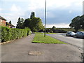
1
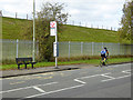
Scots Close northbound bus stop, Town Lane
Served by regular routes 203, 442 and 555 towards Terminal 5 or Hatton Cross.
Image: © Robin Webster
Taken: 22 Oct 2017
0.03 miles
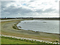
3
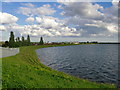
Staines Reservoirs, south basin
The eastern side of the south basin, seen from its north-east corner. Among the buildings visible in the distance is Ashford Hospital.
There was quite a fresh south-west wind blowing, and waves were slapping on the reservoir's eastern shore. Compare Hugh Venables' contribution, looking west (from much the same spot) on a still day: http://www.geograph.org.uk/photo/410849
Image: © Stefan Czapski
Taken: 6 May 2014
0.04 miles
4
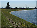
The corner of the reservoir
The corner where the causeway leaves the embankment of the southern part of the reservoir. The crane in the background marks the position of Ashford Hospital where the demolition of the old West Wing was taking place at the time.
Image: © Alan Hunt
Taken: 1 Aug 2013
0.08 miles
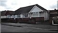
6
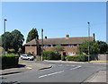
Clyde Road, Stanwell
The junction between Clyde Road and Clare Road. The houses date from the 1960s.
Image: © Alan Hunt
Taken: 1 Aug 2013
0.11 miles
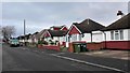
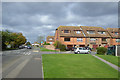
7
Houses near the Reservoir
Not a spectacular view, but one that shows how high the reservoir banks are compared to their surroundings. This is at the eastern end of the 1+ km pathway across Staines Reservoir.
Image: © Des Blenkinsopp
Taken: 6 Jun 2019
0.11 miles
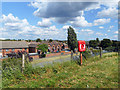
9
Drained southern Staines Reservoir
Drained for maintenance, it is surprising how uneven the floor is.
Image: © Robin Webster
Taken: 22 Oct 2017
0.11 miles
10
Houses on Viola Avenue
Off Town Lane.
Image: © Robin Webster
Taken: 22 Oct 2017
0.13 miles