IMAGES TAKEN NEAR TO
Bedfont Road, STAINES-UPON-THAMES, TW19 7LU
Introduction
This page details the photographs taken nearby to Bedfont Road, TW19 7LU by members of the Geograph project.
The Geograph project started in 2005 with the aim of publishing, organising and preserving representative images for every square kilometre of Great Britain, Ireland and the Isle of Man.

There are currently over 7.5m images from over14,400 individuals and you can help contribute to the project by visiting https://www.geograph.org.uk
Image Map
Images are licensed for reuse under creativecommons.org/licenses/by-sa/2.0
Notes
- Clicking on the map will re-center to the selected point.
- The higher the marker number, the further away the image location is from the centre of the postcode.
Image Listing (48 Images Found)
Images are licensed for reuse under creativecommons.org/licenses/by-sa/2.0
Image
Details
Distance
1
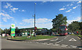
BP Garage, Bedfont Road
At the junction with Clare Road.
Image: © Des Blenkinsopp
Taken: 21 Aug 2015
0.01 miles
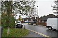
3
Bedfont Road at the junction of Clare Road
Heathrow Airport is on the right
Image: © David Howard
Taken: 26 Aug 2013
0.02 miles
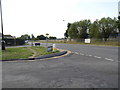
4
Clare Road at the junction of Bedfont Road, Stanwell
Looking towards the cargo area at Heathrow Airport
Image: © David Howard
Taken: 26 Aug 2013
0.03 miles
5
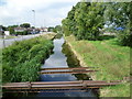
Longford River alongside Bedfont Road
Ahead is the Longford River and hidden by the trees on the right is The Duke of Northumberland's River. To the south of Heathrow Airport and its Southern Perimeter Road, the two waterways run parallel and it is possible to follow a track between them. Here they are known as the Twin Rivers.
Charles I ordered the construction of the totally artificial watercourse known as the Longford River to carry water from the River Colne to the water features in Bushy Park and then on to the Long Water in Home Park at Hampton Court. The Longford River opened in 1638.
This western section of the Duke of Northumberland's River was constructed during the reign of King Henry VIIIth. It takes water from the River Colne and was designed to supplement the flow to existing mills.
The Southern Perimeter Road is beyond the Duke of Northumberland's River to the right and Stanwell Road is here on the left.
Image: © Marathon
Taken: 10 Sep 2014
0.04 miles
6
Longford River alongside Bedfont Road
Ahead is the Longford River and to the left, hidden by the trees, is The Duke of Northumberland's River. To the south of Heathrow Airport and its Southern Perimeter Road, the two waterways run parallel and it is possible to follow a track between them. Here they are known as the Twin Rivers.
Charles I ordered the construction of the totally artificial watercourse known as the Longford River to carry water from the River Colne to the water features in Bushy Park and then on to the Long Water in Home Park at Hampton Court. The Longford River opened in 1638.
This western section of the Duke of Northumberland's River was constructed during the reign of King Henry VIIIth. It takes water from the River Colne and was designed to supplement the flow to existing mills.
Stanwell Road is beyond the Longford River to the right.
Image: © Marathon
Taken: 10 Sep 2014
0.04 miles
7
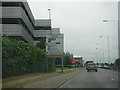
Hillingdon : Southern Perimeter Road
Passing the cargo terminal on the left as we head along the Southern Perimeter Road.
Image: © Lewis Clarke
Taken: 3 Jun 2016
0.06 miles
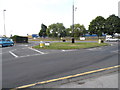
8
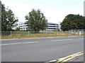
Car Park at Heathrow cargo terminal
From Bedfont Road
Image: © David Howard
Taken: 26 Aug 2013
0.06 miles
9
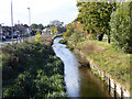
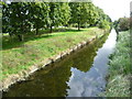
The Longford River
A 17th century artificial cut, here diverted around Heathrow Airport in recent times. It was to supply good water from the River Colne to Hampton Court. Looking upstream, with Bedfont Road on the left.
Image: © Robin Webster
Taken: 22 Oct 2017
0.06 miles
10
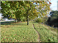
Path between rivers
The Duke of Northumberland's River is on the left. Lower, on the right, the Longford River. Both are here diverted around Heathrow Airport, although both were artificial rivers anyway. The Duke's 16th century river was to augment water supply for his mills by diverting water from the River Colne to the River Crane. The Longford River was dug in the 17th century to supply water to Hampton Court from the River Colne.
Image: © Robin Webster
Taken: 22 Oct 2017
0.06 miles