IMAGES TAKEN NEAR TO
Riverside Place, STAINES-UPON-THAMES, TW19 7LP
Introduction
This page details the photographs taken nearby to Riverside Place, TW19 7LP by members of the Geograph project.
The Geograph project started in 2005 with the aim of publishing, organising and preserving representative images for every square kilometre of Great Britain, Ireland and the Isle of Man.

There are currently over 7.5m images from over14,400 individuals and you can help contribute to the project by visiting https://www.geograph.org.uk
Image Map
Images are licensed for reuse under creativecommons.org/licenses/by-sa/2.0
Notes
- Clicking on the map will re-center to the selected point.
- The higher the marker number, the further away the image location is from the centre of the postcode.
Image Listing (61 Images Found)
Images are licensed for reuse under creativecommons.org/licenses/by-sa/2.0
Image
Details
Distance
1
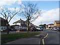
Bedfont Road, Stanwell
From the High Street mini-roundabout junction
Image: © David Howard
Taken: 26 Aug 2013
0.04 miles
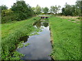
2
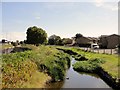
Duke of Northumberland's River
This is near the Southern Perimeter Road of Heathrow Airport.
Image: © Anonymous
Taken: 8 Sep 2009
0.06 miles
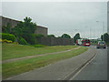
3

Hillingdon : Southern Perimeter Road
Heading along the Southern Perimeter Road as it heads around Heathrow Airport.
Image: © Lewis Clarke
Taken: 3 Jun 2016
0.06 miles
4
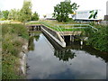
Slipway, Duke of Northumberland's River
The Duke of Northumberland's River is an artificial cut which diverted water from the River Colne to augment the River Crane which used to run a lot of mills.
It isn't navigable, so I'm not sure what this slipway is for. You could canoe on it, I suppose.
Image: © Des Blenkinsopp
Taken: 21 Aug 2015
0.07 miles
5
Hillingdon : Southern Perimeter Road
Heading along the road which goes around the perimeter of Heathrow Airport.
Image: © Lewis Clarke
Taken: 3 Jun 2016
0.09 miles
6
The Duke of Northumberland's River emerges from under Southern Perimeter Road
This is The Duke of Northumberland's River and out of sight on the left is the Longford River - see http://www.geograph.org.uk/photo/4161194 To the south of Heathrow Airport and its Southern Perimeter Road, the two waterways run parallel and it is possible to follow a track between them. Here they are known as the Twin Rivers.
This western section of the Duke of Northumberland's River was constructed during the reign of King Henry VIIIth. It takes water from the River Colne and was designed to supplement the flow to existing mills.
Charles I ordered the construction of the totally artificial watercourse known as the Longford River to carry water from the River Colne to the water features in Bushy Park and then on to the Long Water in Home Park at Hampton Court. The Longford River opened in 1638.
They have followed the north side of the Southern Perimeter Road of Heathrow Airport before passing under the road and emerging here to follow the southern side as far as the Great South-West Road (A30).
Image: © Marathon
Taken: 10 Sep 2014
0.11 miles
7
Southern Perimeter Road, Heathrow Airport, approaching the Sandringham Road junction
Image: © N Chadwick
Taken: 23 Aug 2010
0.11 miles
8
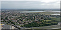
Stanwell from the air
The drained Staines north reservoir is visible. It was drained earlier in the year to enable maintenance work to be carried out.
Image: © Thomas Nugent
Taken: 3 Aug 2015
0.11 miles
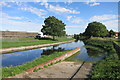
9
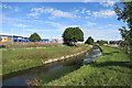
The Longford River
Two man made watercourses, The Duke of Northumberland's and the Longford Rivers, flow side by side along here just a few metres apart.
Both streams are artificial distributaries of the River Colne, made to divert water to be used elsewhere.
The Duke's river augmented water mills on the River Crane, while the Longford River, shown here, supplied clean water to Hampton Court Palace beside the polluted River Thames.
Image: © Des Blenkinsopp
Taken: 21 Aug 2015
0.11 miles
10
The Longford River emerges from under Southern Perimeter Road
This is The Longford River and out of sight on the right is the Duke of Northumberland's River - see http://www.geograph.org.uk/photo/4161185 To the south of Heathrow Airport and its Southern Perimeter Road, the two waterways run parallel and it is possible to follow a track between them. Here they are known as the Twin Rivers.
Charles I ordered the construction of the totally artificial watercourse known as the Longford River to carry water from the River Colne to the water features in Bushy Park and then on to the Long Water in Home Park at Hampton Court. The Longford River opened in 1638.
The western section of the Duke of Northumberland's River was constructed during the reign of King Henry VIIIth. It takes water from the River Colne and was designed to supplement the flow to existing mills.
They have followed the north side of the Southern Perimeter Road of Heathrow Airport before passing under the road and emerging here to follow the southern side as far as the Great South-West Road (A30).
Image: © Marathon
Taken: 10 Sep 2014
0.12 miles