IMAGES TAKEN NEAR TO
Milton Gardens, STAINES-UPON-THAMES, TW19 7BS
Introduction
This page details the photographs taken nearby to Milton Gardens, TW19 7BS by members of the Geograph project.
The Geograph project started in 2005 with the aim of publishing, organising and preserving representative images for every square kilometre of Great Britain, Ireland and the Isle of Man.

There are currently over 7.5m images from over14,400 individuals and you can help contribute to the project by visiting https://www.geograph.org.uk
Image Map
Images are licensed for reuse under creativecommons.org/licenses/by-sa/2.0
Notes
- Clicking on the map will re-center to the selected point.
- The higher the marker number, the further away the image location is from the centre of the postcode.
Image Listing (23 Images Found)
Images are licensed for reuse under creativecommons.org/licenses/by-sa/2.0
Image
Details
Distance
1
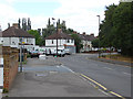
Long Lane, Stanwell
Looking north along Long Lane with the junction of Ravensbourne Avenue in the foreground.
Image: © Alan Hunt
Taken: 24 Jul 2013
0.02 miles
2
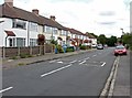
Ravensbourne Avenue, Stanwell
Looking east along Ravensbourne Avenue towards the junction with Long Lane
Image: © Alan Hunt
Taken: 24 Jul 2013
0.07 miles
3
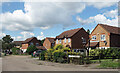
The Nightingales, Stanwell
Part of a residential neighbourhood between Long Lane and Short Lane. The streets are mostly named after birds or authors.
Image: © Des Blenkinsopp
Taken: 15 Aug 2023
0.10 miles
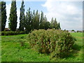
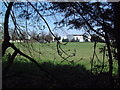
4
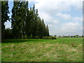
Line of poplars in Long Lane Recreation Ground
The poplars along the southern edge of the recreation ground in Long Lane make an arresting sight.
Image: © Marathon
Taken: 10 Sep 2014
0.12 miles
5
Long Lane Recreation Ground
The poplars along the southern edge of the recreation ground in Long Lane make an arresting sight.
Image: © Marathon
Taken: 10 Sep 2014
0.13 miles
6
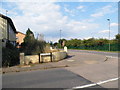
Holywell Way at the junction of Long Lane
The prefab style houses on the left have nearly all been demolished for new blocks of flats, the construction is well over half way completed on the estate.
Image: © David Howard
Taken: 26 Aug 2013
0.14 miles
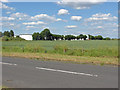
7
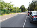
Long Lane, West Bedfont
Ashford Sports Club is behind the railings on the left
Image: © David Howard
Taken: 26 Aug 2013
0.14 miles
8
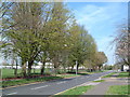
Long Lane
Looking north towards West Bedfont and Heathrow Airport with the recreation ground to the west.
Image: © David Squire
Taken: 22 Apr 2006
0.14 miles
9
Playing Fields off Short Lane
These playing fields are alongside the western boundary of the Esso West London Oil Terminal.
Image: © David Squire
Taken: 22 Apr 2006
0.15 miles
10
Short Lane, West Bedfont
Looking across Short Lane towards the Esso West London storage depot
Image: © Alan Hunt
Taken: 5 Jun 2014
0.16 miles