IMAGES TAKEN NEAR TO
Horton Road, STAINES-UPON-THAMES, TW19 6AF
Introduction
This page details the photographs taken nearby to Horton Road, TW19 6AF by members of the Geograph project.
The Geograph project started in 2005 with the aim of publishing, organising and preserving representative images for every square kilometre of Great Britain, Ireland and the Isle of Man.

There are currently over 7.5m images from over14,400 individuals and you can help contribute to the project by visiting https://www.geograph.org.uk
Image Map
Images are licensed for reuse under creativecommons.org/licenses/by-sa/2.0
Notes
- Clicking on the map will re-center to the selected point.
- The higher the marker number, the further away the image location is from the centre of the postcode.
Image Listing (24 Images Found)
Images are licensed for reuse under creativecommons.org/licenses/by-sa/2.0
Image
Details
Distance
2
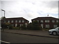
Stanwell Moor village hall
The village hall on Horton Road opposite the junction with Hithermoor Road.
Image: © Alan Hunt
Taken: 16 May 2014
0.08 miles
3

Stanwell Moor Village Hall
Stanwell Moor is a community of mainly 20th century housing sandwiched in between reservoirs, the M25 and Heathrow Airport.
Image: © Des Blenkinsopp
Taken: 6 Jun 2019
0.08 miles
4
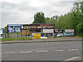
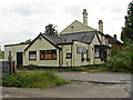
Kestrel, Horton Road, Stanwell Moor
Formerly (?) the Kestrel Hydro naturist spa by day, and the AbFab Swingers Club by night, local council planners ordered that the premises revert to the only permitted use, a private dwelling, and any structures inconsistent with that use be removed (the extensive structures are round behind). After court appeals raised by Kestrel, eventually reaching the Supreme Court about a year ago who rejected a hearing, the council's case was confirmed. The legal point concerned removal of the structures, whether a four year or ten year interval was applicable between the start of works and an enforceable planning order being made. The courts found it was ten years, which scuppered Kestrel.
The notices fixed at remarkably close intervals along the fence appear to be effectively a declaration by Kestrel that no one shall enter the premises, and a council application and court order that the council may enter to see that all structures that are not permitted have been removed.
It is hard to see why Kestrel are so reluctant to allow this, unless they intend to continue operating counter to planning permission. Their web site gives no indication they are closed.
Image: © Robin Webster
Taken: 22 Oct 2017
0.10 miles
5
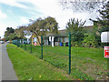
Stanwell Moor - Hethermoor Road
Stream run along the side of the road.
Image: © James Emmans
Taken: 1 Mar 2017
0.11 miles
6
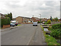
Hithermoor Road
Hithermoor road in Stanwell Moor. There is a stream that runs along the east side of the road necessitating footbridges to allow access to the houses.
Image: © Alan Hunt
Taken: 16 May 2014
0.12 miles
7
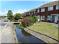
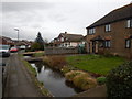
Stream along Hithermoor Road
Yet another watercourse in the maze of millstreams, diversions and alternative channels which make up the River Colne.
This stream appears to flow from the Longford River, itself a Colne distributary, back into the main river on Staines Moor.
Image: © Des Blenkinsopp
Taken: 6 Jun 2019
0.14 miles
8
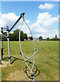
Stanwell Moor Recreation Ground
Sports field and playground behind Stanwell Moor Village Hall.
Image: © Des Blenkinsopp
Taken: 6 Jun 2019
0.15 miles
9
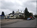
Stanwell Moor - Hethermoor Road
The Hope Inn is looking run down and neglected.
http://www.geograph.org.uk/photo/4008293
Image: © James Emmans
Taken: 1 Mar 2017
0.17 miles
10
Former Hope Inn, Stanwell Moor
The derelict Hope Inn on Hithermoor Road.
Image: © Alan Hunt
Taken: 16 May 2014
0.17 miles