IMAGES TAKEN NEAR TO
Coppice Drive, STAINES-UPON-THAMES, TW19 5JG
Introduction
This page details the photographs taken nearby to Coppice Drive, TW19 5JG by members of the Geograph project.
The Geograph project started in 2005 with the aim of publishing, organising and preserving representative images for every square kilometre of Great Britain, Ireland and the Isle of Man.

There are currently over 7.5m images from over14,400 individuals and you can help contribute to the project by visiting https://www.geograph.org.uk
Image Map
Images are licensed for reuse under creativecommons.org/licenses/by-sa/2.0
Notes
- Clicking on the map will re-center to the selected point.
- The higher the marker number, the further away the image location is from the centre of the postcode.
Image Listing (6 Images Found)
Images are licensed for reuse under creativecommons.org/licenses/by-sa/2.0
Image
Details
Distance
1
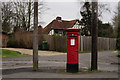
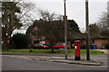
Postbox in Wraysbury
Located at the junction of Garson Lane and Ouseley Road.
Image: © Peter Trimming
Taken: 11 Feb 2015
0.22 miles
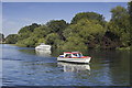
3
Paddle Steamer
French Brothers river trips
Image: © Robert Eva
Taken: 5 Jan 2017
0.22 miles
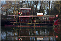
4
Postbox in Wraysbury
Located at the junction of Garson Lane and Ouseley Road.
Image: © Peter Trimming
Taken: 11 Feb 2015
0.23 miles
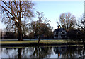
5
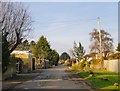
Riverside, Wraysbury
'Riverside' is the name of this residential road - where the properties on the west (left) side all have gardens which run down to the river.
Image: © Stefan Czapski
Taken: 27 Feb 2013
0.24 miles