IMAGES TAKEN NEAR TO
High Street, STAINES-UPON-THAMES, TW19 5DB
Introduction
This page details the photographs taken nearby to High Street, TW19 5DB by members of the Geograph project.
The Geograph project started in 2005 with the aim of publishing, organising and preserving representative images for every square kilometre of Great Britain, Ireland and the Isle of Man.

There are currently over 7.5m images from over14,400 individuals and you can help contribute to the project by visiting https://www.geograph.org.uk
Image Map
Images are licensed for reuse under creativecommons.org/licenses/by-sa/2.0
Notes
- Clicking on the map will re-center to the selected point.
- The higher the marker number, the further away the image location is from the centre of the postcode.
Image Listing (72 Images Found)
Images are licensed for reuse under creativecommons.org/licenses/by-sa/2.0
Image
Details
Distance
4
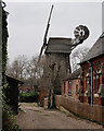
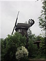
Wraysbury Windmill
Seen from the High Street.
Image: © Peter Trimming
Taken: 11 Feb 2015
0.02 miles
5
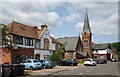
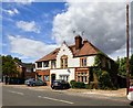
Victorian Buildings, Wraysbury High Street
An eye catching set of buildings from the 19th century in Wraysbury village.
The Baptist Church dates from 1862, while the gabled terrace in the foreground is later. It has a stone above the central window which has the unusual inscription "189 2/8" I can only guess it took six years to build and somebody wanted that recorded.
Image: © Des Blenkinsopp
Taken: 16 May 2023
0.02 miles
6
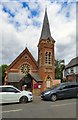
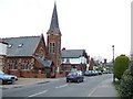
Baptist Church, Wraysbury
Built in 1862 to a design by surveyor William Thomas Buckland.
Image: © Gerald England
Taken: 17 Jul 2018
0.02 miles
7
Baptist Church, Wraysbury
Built in 1862 to a design by surveyor William Thomas Buckland.
Image: © Jim Osley
Taken: 4 Aug 2017
0.02 miles
8
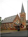
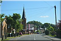
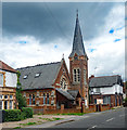
Wraysbury: The Baptist Church
There are several interesting buildings in Wraysbury but very few are nationally listed. This is one of the interesting and surprisingly unlisted ones, a nicely proportioned Victorian church with a fine separate tower, and, on close inspection, both with a lot of intricate and pleasing detail.
Up to and including the map of 1920 the Ordnance Survey spelt Wraysbury as Wyrardisbury, both as the name of the village and as the name of the civil parish. For a while in the 1930s the OS offered both spellings until eventually the modern day one only was accepted.
Image: © Nigel Cox
Taken: 12 Dec 2013
0.02 miles
9
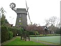
Wraysbury: Splash Windmill
An initial observation suggests this is an old smock windmill but in truth it is very modern, construction having started in 1995 and being completed in 1997. It was the work of Glynn Larcombe, who designed and built it in his own rear garden, partly from his love and admiration of large agricultural buildings, and but also in protest against the loss of local heritage within Wraysbury. It was inspired by Image It is currently in use as self-catering rented accommodation.
The name of the windmill possibly comes from its very close proximity to Image
Image: © Nigel Cox
Taken: 12 Dec 2013
0.03 miles