IMAGES TAKEN NEAR TO
Moor Lane, STAINES-UPON-THAMES, TW18 4YU
Introduction
This page details the photographs taken nearby to Moor Lane, TW18 4YU by members of the Geograph project.
The Geograph project started in 2005 with the aim of publishing, organising and preserving representative images for every square kilometre of Great Britain, Ireland and the Isle of Man.

There are currently over 7.5m images from over14,400 individuals and you can help contribute to the project by visiting https://www.geograph.org.uk
Image Map (180 Images)


Leaflet Map data © OpenStreetMap
Images are licensed for reuse under creativecommons.org/licenses/by-sa/2.0
Notes
- Clicking on the map will re-center to the selected point.
- The higher the marker number, the further away the image location is from the centre of the postcode.
Image Listing (180 Images Found)
Images are licensed for reuse under creativecommons.org/licenses/by-sa/2.0
Image
Details
Distance
1
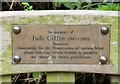
Plaque on Judi Giffin Memorial Bench
Judi Giffin Memorial Bench is on a public footpath between Vicarage Road and Moor Lane.
Image: © Sean Davis
Taken: 24 Aug 2012
0.05 miles
2
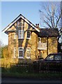
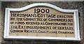
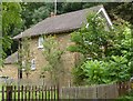
Herdsman's Cottage, Moor Lane - otherwise known as Moor Lodge
The plaque on the gable carries the following inscription:
1900
HERDSMAN'S COTTAGE ERECTED
BY THE COMMITTEE OF COMMONERS OUT
OF FUNDS RECEIVED IN COMPENSATION FOR
THE EXTINGUISHMENT OF CERTAIN
COMMON RIGHTS.
CHAS. F. LEAKE. CHAIRMAN
Despite that history the present owners prefer to call the place Moor Lodge.
Image: © Stefan Czapski
Taken: 29 Dec 2013
0.05 miles
3
Commemorative plaque, Herdsman's Cottage, Moor Lane, Staines
A detail of the house seen in: Image
Image: © Stefan Czapski
Taken: 29 Dec 2013
0.05 miles
4
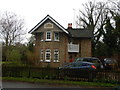
Detached House on Moor Lane
Around 1900 a Sheppard lost his grazing rights and this house was built as compensation. The Sheppard seems to be doing extremely well these days with not one but two Range Rovers.
Wikipedia : https://en.wikipedia.org/wiki/Staines_Moor
Image: © James Emmans
Taken: 27 Feb 2017
0.05 miles
5
Plaque on Herdsman's Cottage
Plaque on front of Herdsman's Cottage at Moor Lane in Staines. See https://www.geograph.org.uk/photo/6423661
Image: © Sean Davis
Taken: 24 Aug 2012
0.06 miles
6
Herdman's Cottage
Herdman's Cottage on Moor Lane, Staines. The two storey house retains its original design and is a Grade II listed building. It was originally known as Moor Lodge and as the name suggests, it was here the “Keeper (or Warden) of Staines Moor” lived. On the top front of the house is a plaque inscribed
“1900. Herdsman’s Cottage erected by the Committee of Commoners out of funds received as compensation for the extinguishing of certain Common Rights Chas, F. Leake, Chairman.” See https://www.geograph.org.uk/photo/6423651
Image: © Sean Davis
Taken: 24 Aug 2012
0.06 miles
8
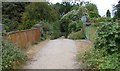
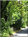
Track from Staines Moor to Moor Lane
The wide track leads to Moor Lane. Photo is taken from the “Cattle Bridge” or Drover’s Bridge. This consists of three bridges of different dates joined end to end and built between c1840 and 1885. There is a plate girder bridge over the now closed Great Western Railway and Staines Aqueduct, a bridge with two yellow brick arches over the Wraysbury River and a single red brick span over the Southern Railway Staines to Windsor line. This access bridge is the largest surviving monument to the importance of the moor.
Image: © Sean Davis
Taken: 24 Aug 2012
0.06 miles
10
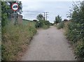
Track to Staines Moor
The wide track leads uphill, from Herdsman's Cottage at Moor Lane, and over three bridges of different dates joined end to end and built between c1840 and 1885. There is a plate girder bridge over the now closed Great Western Railway and Staines Aqueduct, a bridge with two yellow brick arches over the Wraysbury River and a single red brick span over the Southern Railway Staines to Windsor line. This access bridge is the largest surviving monument to the importance of the moor and is known locally as the “Cattle Bridge” or Drover’s Bridge.
Image: © Sean Davis
Taken: 24 Aug 2012
0.07 miles