IMAGES TAKEN NEAR TO
Hale Street, STAINES-UPON-THAMES, TW18 4UW
Introduction
This page details the photographs taken nearby to Hale Street, TW18 4UW by members of the Geograph project.
The Geograph project started in 2005 with the aim of publishing, organising and preserving representative images for every square kilometre of Great Britain, Ireland and the Isle of Man.

There are currently over 7.5m images from over14,400 individuals and you can help contribute to the project by visiting https://www.geograph.org.uk
Image Map
Images are licensed for reuse under creativecommons.org/licenses/by-sa/2.0
Notes
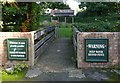
- Clicking on the map will re-center to the selected point.
- The higher the marker number, the further away the image location is from the centre of the postcode.
Image Listing (328 Images Found)
Images are licensed for reuse under creativecommons.org/licenses/by-sa/2.0
Image
Details
Distance
1
Footbridge from Two Rivers Pub to Beer Garden
The footbridge from Two Rivers Pub, over the Wraysbury River, to the beer garden. The River Colne flows past the opposite side of the beer garden. Both rivers join just to the right of the beer garden.
Image: © Sean Davis
Taken: 12 Oct 2012
0.03 miles
2
Pub Bridge over Wraysbury River
This is the old footbridge from the Two Rivers Pub, on Church Street, which links it to its beer garden on the other side of the Wraysbury River. The opposite side of the beer garden overlooks the River Colne.
Image: © Sean Davis
Taken: 12 Oct 2012
0.03 miles
4
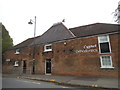
Staines: Former malthouse in Wraysbury Road
With Image looming in the distance and the Pound Mill sculpture in the left foreground, the building is currently occupied by Cygnet Orthodontics.
Image: © Nigel Cox
Taken: 20 Jun 2010
0.05 miles
6
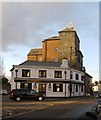
Former pub and converted brewery, Church Street, Staines
The pub - at the corner of Bridge Street - was once 'The Cock'. It is certainly a handsome building, perhaps dating from about 1825. The tall building beyond it - now residential - is said to have been the old Ashby's brewery. The Staines firm was acquired by Simonds in about 1930, the estate subsequently passing into the hands of Courage. http://ashbybugbrooke.blogspot.co.uk/2012/04/ashby-breweries-history.html
Image: © Stefan Czapski
Taken: 9 Jan 2014
0.05 miles
7
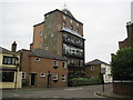
Staines: Former Ashby's Brewery
Ashby's Brewery functioned in Staines up until about 1930 and this building in Church Street with its distinctive crown shaped metal cap is, I think, one of the brewery's buildings. Records of the building on the internet are sparse as it surprisingly does not appear to be a Listed Building. After it ceased being a brewery it may have been used as an office by Courage, but has since been converted into flats.
Image: © Nigel Cox
Taken: 20 Jun 2010
0.06 miles
8
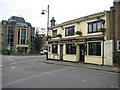
Staines: The Cock
The Cock is a Jack Beard's managed pub in Church Street.
Image: © Nigel Cox
Taken: 20 Jun 2010
0.06 miles
9
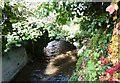
Sweeps Ditch at Staines
Just east of the footbridge which joins Two Rivers Shopping Centre to Church Street, and where the Colne and Wraysbury rivers meet is a small section of a dried up water channel. This was from where the River Colne originally fed Sweeps Ditch.
Sweeps Ditch was an ancient man-made mill stream or defence ditch which flowed through Staines. In Roman & Medieval Times it formed the western and northern boundary of Town Island (sometimes referred to as High Street Island). However, with the building of the Elmsleigh Shopping Centre and the redevelopment of the town centre in the 1970s, the water source was cut. A new water source was provided by Thames Water in 1982, when it installed a pump house in the Riverside car park and this takes water from the Thames. However, the stream no longer goes through the centre of the town, instead it goes underground in a pipe across Thames Street and South Street and re-emerges to the south-east of the town centre, before flowing east and south to rejoin the Thames over a mile downstream near Penton Hook Lock.
Image: © Sean Davis
Taken: 6 Nov 2012
0.06 miles
10
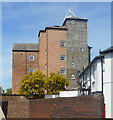
Ashby's Brewery
This large town centre tower brewery ceased production as long ago as 1936, but the building has survived and is now apartments.
Brewery history on http://www.thamessidebrewery.co.uk/history.html which is from the Thames Side Brewery, a new company now brewing nearby.
Image: © Des Blenkinsopp
Taken: 10 May 2017
0.06 miles