IMAGES TAKEN NEAR TO
Norris Road, STAINES-UPON-THAMES, TW18 4UP
Introduction
This page details the photographs taken nearby to Norris Road, TW18 4UP by members of the Geograph project.
The Geograph project started in 2005 with the aim of publishing, organising and preserving representative images for every square kilometre of Great Britain, Ireland and the Isle of Man.

There are currently over 7.5m images from over14,400 individuals and you can help contribute to the project by visiting https://www.geograph.org.uk
Image Map
Images are licensed for reuse under creativecommons.org/licenses/by-sa/2.0
Notes
- Clicking on the map will re-center to the selected point.
- The higher the marker number, the further away the image location is from the centre of the postcode.
Image Listing (205 Images Found)
Images are licensed for reuse under creativecommons.org/licenses/by-sa/2.0
Image
Details
Distance
1

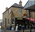
Elmsleigh Shopping Centre Entrance
This impressive entrance is on Staines High Street.
The complex was opened in 1980 by Her Majesty The Queen.
Image: © mike smith
Taken: 4 Aug 2013
0.04 miles
2
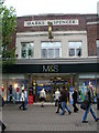
Marks and Spencer, Staines
A particularly beautiful and distinctive shop front design
Image: © Ruth Sharville
Taken: 29 May 2010
0.04 miles
3
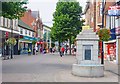
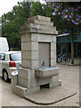
Staines High Street
The High Street is now fully pedestrianised. On the right is the old drinking fountain. It is no longer in use, but the structure is kept as a monument.
Image: © mike smith
Taken: 4 Aug 2013
0.05 miles
4
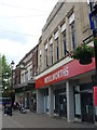
Former Woolworths store, Staines
The chain has been closed for many months, but the sign remains for the much loved family High Street shop.
Image: © Ruth Sharville
Taken: 30 May 2010
0.05 miles
6
Tilly's House, Tilly's Lane, Staines
Tilly’s Lane is named after a 19th century barber. Tilly's House is half way along, on the right, and is now a cafe. With the redevelopment on the High Street and the building of Two Rivers Shopping Centre, Tilly's Lane was widened and the house was preserved by taking it down brick by brick and rebuilding it where it now sits. Excavations here, at the time, revealed Romano-British settlement established in the second half of the 1st century AD, soon after the Roman invasion of Britain in 43 AD.
Image: © Sean Davis
Taken: 17 Sep 2012
0.05 miles
7
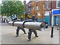
Monument to Staines Linoleum
The town was a major producer of linoleum after the formation of the Linoleum Manufacturing Company in 1864 by its inventor, Frederick Walton. Linoleum became the main industry of the town and was a major employer in the area until the 1960s. This monument or statue is in Staines High Street.
Image: © mike smith
Taken: 4 Aug 2013
0.06 miles
8
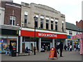
Woolworths shop front in Staines - sadly without the merchandise inside
Woolworths has long since ceased trading, but in Staines the formidable shop building still has the sign to remind us of what is no more.
Image: © Ruth Sharville
Taken: 29 May 2010
0.06 miles
10
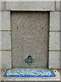
Drinking water fountain, High Street (detail)
See Image The inscription reads "ERECTED / BY PUBLIC SUBSCRIPTIONS / 1885".
Image: © Mike Quinn
Taken: 8 Aug 2018
0.06 miles