IMAGES TAKEN NEAR TO
Lark Avenue, STAINES-UPON-THAMES, TW18 4RX
Introduction
This page details the photographs taken nearby to Lark Avenue, TW18 4RX by members of the Geograph project.
The Geograph project started in 2005 with the aim of publishing, organising and preserving representative images for every square kilometre of Great Britain, Ireland and the Isle of Man.

There are currently over 7.5m images from over14,400 individuals and you can help contribute to the project by visiting https://www.geograph.org.uk
Image Map
Images are licensed for reuse under creativecommons.org/licenses/by-sa/2.0
Notes
- Clicking on the map will re-center to the selected point.
- The higher the marker number, the further away the image location is from the centre of the postcode.
Image Listing (54 Images Found)
Images are licensed for reuse under creativecommons.org/licenses/by-sa/2.0
Image
Details
Distance
1
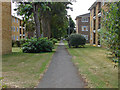
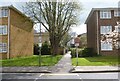
Moormede Estate, Staines
1970s flats and walkway in the Moormede Estate.
Image: © Alan Hunt
Taken: 13 Aug 2013
0.03 miles
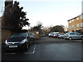
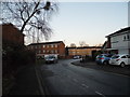
3
Waters Drive, Staines
It is called Waters as it is between the river Ash behind here and Colne on the right. This end of the road is in the place where the two join.
Image: © David Howard
Taken: 18 Jan 2015
0.06 miles
4
Disused bridge
A disused bridge over the Staines reservoirs aqueduct. The site of the BEA Trident crash in 1972 is in the meadow on the other side of the bridge.
Image: © Alan Hunt
Taken: 13 Aug 2013
0.06 miles
5
Footpath from Waters Drive
This footpath from Waters Drive, in Staines-upon-Thames, leads to a small industrial estate at Mill Mead. This is on the route of The Freedom Trail long-distance path.
Image: © Sean Davis
Taken: 19 Apr 2013
0.06 miles
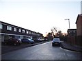
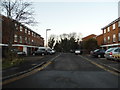
7
Waters Drive at the junction of Kingfisher Drive, Staines
Image: © David Howard
Taken: 18 Jan 2015
0.08 miles
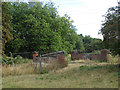
9
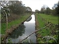
Staines Reservoirs Aqueduct (1)
The aqueduct was completed around 1900 to take water from the River Thames, about 300 metres upstream of Bell Weir Lock in Image, about 3 kilometres downstream to the two new Staines Reservoirs. Sections of the aqueduct are in tunnels with siphons and some reaches such as this are open. This is the view from the public footpath along the River Colne.
Image: © Nigel Cox
Taken: 23 Mar 2014
0.08 miles
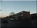
10
Plover Close
A 1970s close in the Moormede estate
Image: © Alan Hunt
Taken: 13 Aug 2013
0.08 miles