IMAGES TAKEN NEAR TO
London Road, STAINES-UPON-THAMES, TW18 4JY
Introduction
This page details the photographs taken nearby to London Road, TW18 4JY by members of the Geograph project.
The Geograph project started in 2005 with the aim of publishing, organising and preserving representative images for every square kilometre of Great Britain, Ireland and the Isle of Man.

There are currently over 7.5m images from over14,400 individuals and you can help contribute to the project by visiting https://www.geograph.org.uk
Image Map
Images are licensed for reuse under creativecommons.org/licenses/by-sa/2.0
Notes
- Clicking on the map will re-center to the selected point.
- The higher the marker number, the further away the image location is from the centre of the postcode.
Image Listing (10 Images Found)
Images are licensed for reuse under creativecommons.org/licenses/by-sa/2.0
Image
Details
Distance
1
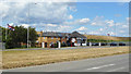
MOT & Service, London Road
Motor trade premises on a narrow site between a reservoir embankment and the A30.
Image: © Des Blenkinsopp
Taken: 6 Jun 2019
0.00 miles
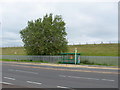
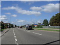
2
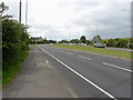
A30, London Road
A view eastwards along the A30 between Ashford and the Croked Billet roundabout in Staines. Staines reservoir lies to the north of the road.
Image: © Alan Hunt
Taken: 27 Jun 2012
0.02 miles
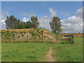
3
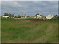
Hengrove Farm
The conveyors and plant sheds of the gravel pits at Hengrove Farm. The lamp standards in the background mark the line of the A30.
Image: © Alan Hunt
Taken: 6 Aug 2012
0.10 miles
4
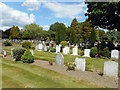
Very neat Staines Cemetery
A well looked after burial ground on the edge of Staines.
Image: © Des Blenkinsopp
Taken: 6 Jun 2019
0.16 miles
5
A30, London Road
A bus stop on the eastbound carriageway of the A30 with the bank on the Staines reservoir in the background.
Image: © Alan Hunt
Taken: 27 Jun 2012
0.17 miles
6
Gravel pit banking
The banks around the gravel pits to the north east of Ashford Park
Image: © Alan Hunt
Taken: 6 Aug 2012
0.20 miles
7
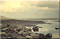
Rubble revealed when the south reservoir was drained
In the 1970s it was possible to fish in the reservoirs, the Civil Service Angling Association having the rights dating back many years. This photograph was taken around 1970.
Image: © David Redwood
Taken: 1 Jan 1972
0.20 miles
8
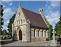
Staines cemetery
The chapel of remembrance in the cemetery on the A30 London Road.
Image: © Alan Hunt
Taken: 29 Jul 2013
0.20 miles
9
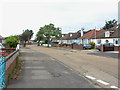
Kenilworth Road
A view along Kenilworth Road, a residential road in Ashford.
Image: © Alan Hunt
Taken: 27 Jun 2012
0.24 miles
10
The A30 heading towards the M25
Adjacent to the Staines reservoirs.
Image: © James Denham
Taken: 30 Aug 2010
0.25 miles