IMAGES TAKEN NEAR TO
High Street, STAINES-UPON-THAMES, TW18 4BY
Introduction
This page details the photographs taken nearby to High Street, TW18 4BY by members of the Geograph project.
The Geograph project started in 2005 with the aim of publishing, organising and preserving representative images for every square kilometre of Great Britain, Ireland and the Isle of Man.

There are currently over 7.5m images from over14,400 individuals and you can help contribute to the project by visiting https://www.geograph.org.uk
Image Map
Images are licensed for reuse under creativecommons.org/licenses/by-sa/2.0
Notes
- Clicking on the map will re-center to the selected point.
- The higher the marker number, the further away the image location is from the centre of the postcode.
Image Listing (101 Images Found)
Images are licensed for reuse under creativecommons.org/licenses/by-sa/2.0
Image
Details
Distance
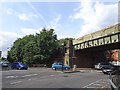
1
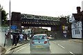
High Street runs under the Iron Bridge
Image: © Steve Daniels
Taken: 30 May 2015
0.02 miles
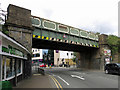
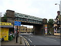
2

The Iron Bridge, Staines
The original iron bridge erected here in 1844 was an arched cast-iron construction – the angled stone plates still form part of the walls under the bridge. The older bridge was replaced by “The Iron Bridge” in the early 20th century as double-decker buses could only get under the original bridge by driving in the middle of the road.
Image: © Sean Davis
Taken: 24 Aug 2012
0.02 miles
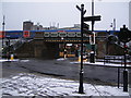
6
Staines High Street railway station (site), Surrey
Opened in 1884 by the London & South Western Railway on the line from Richmond to Windsor & Eton Riverside, this station closed in 1916.
View north from the road. Being on an embankment, most of the construction would have been of wood. Although the railway line is very much in uses, no trace of the former station apparently remains. For more detail, see http://www.disused-stations.org.uk/s/staines_high_street/
Image: © Nigel Thompson
Taken: 8 Jul 2019
0.03 miles
7
Iron railway bridge in Staines town centre
Image: © Ruth Sharville
Taken: 29 May 2010
0.03 miles
8
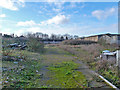
Vacant site, Fairfield Avenue, Staines
Now built on.
Image: © Robin Webster
Taken: 17 Jan 2015
0.04 miles
9

Modern development on High Street, Staines
Image: © David Martin
Taken: 30 Jan 2023
0.05 miles
10
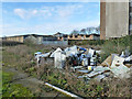
Rubbish on vacant site, Fairfield Avenue, Staines
Now built on - the site, not the rubbish.
Image: © Robin Webster
Taken: 17 Jan 2015
0.05 miles