IMAGES TAKEN NEAR TO
Two Rivers Retail Park, Mustard Mill Road, STAINES-UPON-THAMES, TW18 4BL
Introduction
This page details the photographs taken nearby to Two Rivers Retail Park, Mustard Mill Road, TW18 4BL by members of the Geograph project.
The Geograph project started in 2005 with the aim of publishing, organising and preserving representative images for every square kilometre of Great Britain, Ireland and the Isle of Man.

There are currently over 7.5m images from over14,400 individuals and you can help contribute to the project by visiting https://www.geograph.org.uk
Image Map
Images are licensed for reuse under creativecommons.org/licenses/by-sa/2.0
Notes
- Clicking on the map will re-center to the selected point.
- The higher the marker number, the further away the image location is from the centre of the postcode.
Image Listing (248 Images Found)
Images are licensed for reuse under creativecommons.org/licenses/by-sa/2.0
Image
Details
Distance
1
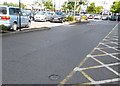
Sweeps Ditch Discs across Two Rivers Car Park
The Sweeps Ditch Stone outside the entrance to VUE Cinema and 15 round discs on the ground throughout the Two Rivers car park, indicate the original route of Sweeps Ditch.
Sweeps Ditch is an ancient man-made mill stream which flowed through Staines. In Roman & Medieval Times it formed the western and northern boundary of Town Island (sometimes referred to as High Street Island).
Image: © Sean Davis
Taken: 14 Sep 2012
0.02 miles
2
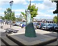
Two River Sprites
The Two River Sprites statue is a sculpture by David Backhouse and was placed here in 2001. The plaque next to the sculpture reads: “The “Two River Sprites” emerge from the water, hands linked. Their meeting is symbolic of the vitality and life of the waterways which converge on this site”.
Image: © Sean Davis
Taken: 14 Sep 2012
0.02 miles
3
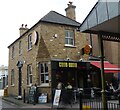
Tilly's House, Tilly's Lane, Staines
Tilly’s Lane is named after a 19th century barber. Tilly's House is half way along, on the right, and is now a cafe. With the redevelopment on the High Street and the building of Two Rivers Shopping Centre, Tilly's Lane was widened and the house was preserved by taking it down brick by brick and rebuilding it where it now sits. Excavations here, at the time, revealed Romano-British settlement established in the second half of the 1st century AD, soon after the Roman invasion of Britain in 43 AD.
Image: © Sean Davis
Taken: 17 Sep 2012
0.03 miles
4
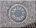
Sweeps Ditch Disc at Two Rivers Car Park
The Sweeps Ditch Stone outside the entrance to VUE Cinema and 15 of these round discs on the ground throughout the Two Rivers car park, indicate the original route of Sweeps Ditch.
Sweeps Ditch is an ancient man-made mill stream which flowed through Staines. In Roman & Medieval Times it formed the western and northern boundary of Town Island (sometimes referred to as High Street Island).
Image: © Sean Davis
Taken: 14 Sep 2012
0.04 miles
5
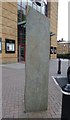
Sweeps Ditch Stone
The Sweeps Ditch Stone is outside the entrance to VUE Cinema. The stone and 15 round plaques, found on the ground throughout the Two Rivers car park, indicate the original route of Sweeps Ditch.
Sweeps Ditch is an ancient man-made mill stream which flowed through Staines. In Roman & Medieval Times it formed the western and northern boundary of Town Island (sometimes referred to as High Street Island).
Image: © Sean Davis
Taken: 14 Sep 2012
0.04 miles
6
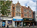
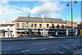
Pedestrainised shopping centre, Staines
The white building is the old Angel Hotel.
Image: © Ruth Sharville
Taken: 30 May 2010
0.05 miles
7
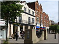
Some splendid old shop fronts, Staines
Image: © Ruth Sharville
Taken: 30 May 2010
0.05 miles
8
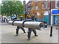
Monument to Staines Linoleum
The town was a major producer of linoleum after the formation of the Linoleum Manufacturing Company in 1864 by its inventor, Frederick Walton. Linoleum became the main industry of the town and was a major employer in the area until the 1960s. This monument or statue is in Staines High Street.
Image: © mike smith
Taken: 4 Aug 2013
0.06 miles
9
Sweeps Ditch at Staines
Just east of the footbridge which joins Two Rivers Shopping Centre to Church Street, and where the Colne and Wraysbury rivers meet is a small section of a dried up water channel. This was from where the River Colne originally fed Sweeps Ditch.
Sweeps Ditch was an ancient man-made mill stream or defence ditch which flowed through Staines. In Roman & Medieval Times it formed the western and northern boundary of Town Island (sometimes referred to as High Street Island). However, with the building of the Elmsleigh Shopping Centre and the redevelopment of the town centre in the 1970s, the water source was cut. A new water source was provided by Thames Water in 1982, when it installed a pump house in the Riverside car park and this takes water from the Thames. However, the stream no longer goes through the centre of the town, instead it goes underground in a pipe across Thames Street and South Street and re-emerges to the south-east of the town centre, before flowing east and south to rejoin the Thames over a mile downstream near Penton Hook Lock.
Image: © Sean Davis
Taken: 6 Nov 2012
0.06 miles
10
The George, Staines
On the High Street.
Image: © Robin Webster
Taken: 17 Jan 2015
0.06 miles