IMAGES TAKEN NEAR TO
Hythe Road, STAINES-UPON-THAMES, TW18 3ED
Introduction
This page details the photographs taken nearby to Hythe Road, TW18 3ED by members of the Geograph project.
The Geograph project started in 2005 with the aim of publishing, organising and preserving representative images for every square kilometre of Great Britain, Ireland and the Isle of Man.

There are currently over 7.5m images from over14,400 individuals and you can help contribute to the project by visiting https://www.geograph.org.uk
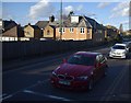
Image Map
Images are licensed for reuse under creativecommons.org/licenses/by-sa/2.0
Notes
- Clicking on the map will re-center to the selected point.
- The higher the marker number, the further away the image location is from the centre of the postcode.
Image Listing (117 Images Found)
Images are licensed for reuse under creativecommons.org/licenses/by-sa/2.0
Image
Details
Distance
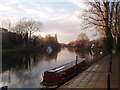
2
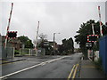
Egham Hythe: Thorpe Road level crossing
Even though it was a very wet day this view of the level crossing is surprisingly devoid of traffic and pedestrians.
Image: © Nigel Cox
Taken: 5 Aug 2008
0.09 miles
3
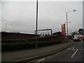
Roundabout at the entrance to Sainsbury's on The Causeway
Image: © David Howard
Taken: 3 Feb 2013
0.09 miles
4
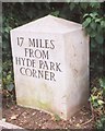
Modern Milestone by the A308, The Causeway, Staines
Carved stone post by the A308, in parish of STAINES (RUNNYMEDE District), 100m West of Staines Bridge, at Sainsbury's Roundabout off The Causeway, in shrubbery by bus stop behind pavement, on South side of road. Modern copy erected by the Egham & Bagshot turnpike trust in the 20th century.
Inscription reads:-
17 MILES
FROM
HYDE PARK
CORNER
Milestone Society National ID: SY_LE17R.
Image: © A Rosevear
Taken: 24 Aug 2002
0.10 miles
5
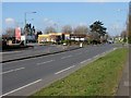
The Causeway, Staines
The road running through the industrial estate towards the M25 to the west of Staines. There used to be a causeway that followed the line of the present road in the 19th century.
Image: © Alan Hunt
Taken: 14 Mar 2013
0.10 miles
6
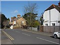
Goring Road
The junction of Goring Road with Thorpe Road.
Image: © Alan Hunt
Taken: 14 Mar 2013
0.11 miles
7
Egham Causeway
The elevated pavement is what is left of an old causeway which leads from The Hythe at Staines to The Glantly at Egham. It was built in the 13th century in the reign of Henry III (1216 – 1272) by a merchant named Thomas de Oxenford. This was for the safe conveyance of his wool and other merchandise to and from London markets. The causeway supported a road above the Egham flood-plain and also acted as a dyke to protect the surrounding area from flooding. Some sources also credit de Oxenford for building a bridge over the River Thames from Staines to Egham Hythe in the early 13th century.
Image: © Sean Davis
Taken: 14 Aug 2012
0.11 miles
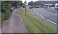
9
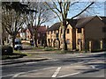
Avenue Road, Staines
The residential road off the Causeway to the west of Staines.
Image: © Alan Hunt
Taken: 14 Mar 2013
0.12 miles
10
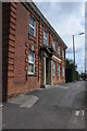
Georgian-style house, Staines
Georgian-style house built in 1914 situated on The Causeway in Staines.
Image: © Philip Halling
Taken: 29 Aug 2011
0.12 miles