IMAGES TAKEN NEAR TO
Burges Way, STAINES-UPON-THAMES, TW18 2EX
Introduction
This page details the photographs taken nearby to Burges Way, TW18 2EX by members of the Geograph project.
The Geograph project started in 2005 with the aim of publishing, organising and preserving representative images for every square kilometre of Great Britain, Ireland and the Isle of Man.

There are currently over 7.5m images from over14,400 individuals and you can help contribute to the project by visiting https://www.geograph.org.uk
Image Map
Images are licensed for reuse under creativecommons.org/licenses/by-sa/2.0
Notes
- Clicking on the map will re-center to the selected point.
- The higher the marker number, the further away the image location is from the centre of the postcode.
Image Listing (26 Images Found)
Images are licensed for reuse under creativecommons.org/licenses/by-sa/2.0
Image
Details
Distance
3
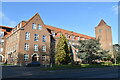
Spelthorne Council Offices, Staines
A rather impressive building, opened in 1972 for Staines Urban District Council, which was itself abolished in the 1974 local government reorganization.
Image: © David Martin
Taken: 30 Jan 2023
0.16 miles
4
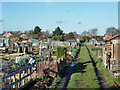
Allotments, Staines
Off Commercial Road.
Image: © Robin Webster
Taken: 17 Jan 2015
0.19 miles
5
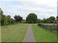
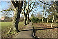
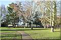
Staines Park
A view of the park off Commercial Road in the Knowle Green area of Staines.
Image: © Alan Hunt
Taken: 27 Jun 2012
0.19 miles
6
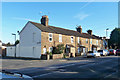
Terrace on Laleham Road
Called 'Langley Place' on the central stone, with no date, but the houses appeared on maps by 1894.
Image: © Robin Webster
Taken: 17 Jan 2015
0.19 miles
7
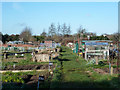
Allotments, Staines
Off Commercial Road.
Image: © Robin Webster
Taken: 17 Jan 2015
0.19 miles
9
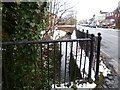
Sweeps Ditch from Gresham Road
Sweeps Ditch flows in front of houses along Budebury Road. Photo taken from Gresham Road, note the snow on the ground.
Sweeps Ditch is an ancient man-made mill stream which flowed through Staines. In Roman & Medieval Times it formed the western and northern boundary of Town Island (sometimes referred to as High Street Island).
Image: © Sean Davis
Taken: 21 Jan 2013
0.20 miles
10
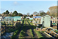
Allotments beside Commercial Road, Staines
Image: © David Martin
Taken: 30 Jan 2023
0.20 miles