IMAGES TAKEN NEAR TO
Grange Place, STAINES-UPON-THAMES, TW18 1RY
Introduction
This page details the photographs taken nearby to Grange Place, TW18 1RY by members of the Geograph project.
The Geograph project started in 2005 with the aim of publishing, organising and preserving representative images for every square kilometre of Great Britain, Ireland and the Isle of Man.

There are currently over 7.5m images from over14,400 individuals and you can help contribute to the project by visiting https://www.geograph.org.uk
Image Map
Images are licensed for reuse under creativecommons.org/licenses/by-sa/2.0
Notes
- Clicking on the map will re-center to the selected point.
- The higher the marker number, the further away the image location is from the centre of the postcode.
Image Listing (17 Images Found)
Images are licensed for reuse under creativecommons.org/licenses/by-sa/2.0
Image
Details
Distance
1
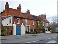
Terrace of red-brick cottages, in the Broadway, Laleham
Known as Cambridge Cottage and the Red Cottage. Pleasant, modest little cottages - though the classical porticos suggest a bit of social climbing, perhaps circa 1800! Grade II listed: http://www.britishlistedbuildings.co.uk/en-363216-cambridge-and-the-red-cottage-surrey
The area is now largely suburbanised, but quite a few old (or oldish) buildings survive around the original village centre, so that the place still has character.
Image: © Stefan Czapski
Taken: 25 Nov 2012
0.08 miles
2
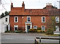
Cambridge Cottage, The Broadway, Laleham
One of a pair of red-brick cottages toward the northern end of the old village centre. The listing text suggests a date before 1800: http://www.britishlistedbuildings.co.uk/en-363216-cambridge-and-the-red-cottage-surrey
For a wider view, see: Image
Image: © Stefan Czapski
Taken: 25 Nov 2012
0.08 miles
3
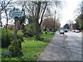
Laleham Village
The start of Laleham village approaching from the north east along The Broadway.
Image: © David Squire
Taken: 22 Apr 2006
0.08 miles
4
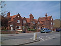
School Cottages
These houses are situated on the north side of The Broadway as it leaves the village. Note the Lucan coat of arms on the gables.
Image: © David Squire
Taken: 22 Apr 2006
0.08 miles
5
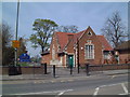
Laleham School
Laleham Church of England School was opened in 1865, the land having been given by the Third Earl of Lucan. A new junior school was built in the playground in 1959 and a further extension block was added in 1977.
Image: © David Squire
Taken: 22 Apr 2006
0.08 miles
6
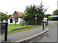
Laleham Village Hall and car park, The Broadway
Image: © David Howard
Taken: 2 Sep 2012
0.14 miles
7
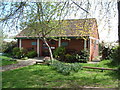
Heritage Centre
Historical memorabilia of the village and the local area are on display and there is a wildlife garden behind the centre. Books on the history of Laleham are available, and guided walks around the village start here. Part of the building is also the parish office.
Image: © David Squire
Taken: 22 Apr 2006
0.17 miles
8
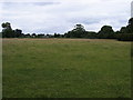
Field by Staines Road
Field by Staines Road Laleham
Image: © Shaun Ferguson
Taken: 18 Jun 2008
0.22 miles
9
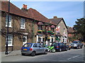
Turk's Head
The pub has beautiful hanging baskets throughout the summer months. Adjacent are Wisteria Cottage and the Corner House, both listed buildings.
Image: © David Squire
Taken: 22 Apr 2006
0.22 miles
10
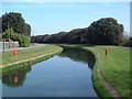
Intake Channel
This channel leads from the River Thames to the Queen Mary Reservoir, a distance of about one kilometre. As the reservoir water level is at least 10 metres higher than the river there is a pumping station at the eastern end.
Image: © David Squire
Taken: 22 Apr 2006
0.23 miles