IMAGES TAKEN NEAR TO
Hamhaugh Island, SHEPPERTON, TW17 9LP
Introduction
This page details the photographs taken nearby to Hamhaugh Island, TW17 9LP by members of the Geograph project.
The Geograph project started in 2005 with the aim of publishing, organising and preserving representative images for every square kilometre of Great Britain, Ireland and the Isle of Man.

There are currently over 7.5m images from over14,400 individuals and you can help contribute to the project by visiting https://www.geograph.org.uk
Image Map
Images are licensed for reuse under creativecommons.org/licenses/by-sa/2.0
Notes
- Clicking on the map will re-center to the selected point.
- The higher the marker number, the further away the image location is from the centre of the postcode.
Image Listing (144 Images Found)
Images are licensed for reuse under creativecommons.org/licenses/by-sa/2.0
Image
Details
Distance
1
Weybridge Rowing Club
Historic club at Jessamy Road, Thames Lock in Weybridge.
www.weybridgerowing.club
Image: © Colin Smith
Taken: 8 Jul 2022
0.06 miles
2
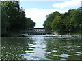
Weir on the Thames at Shepperton Lock
Weir on the Thames at Shepperton Lock.
Image: © Graham Newell
Taken: 15 Aug 2007
0.07 miles
3
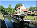
Weybridge - Thames Lock
Narrowboat on the River Wey Navigation, passing through the last lock before the Wey meets the Thames. The first Thames Lock was built in 1653, rebuilt in 1863 and renovated in 1996. Pleasure craft have long replaced the former barge traffic between London and Guildford.
www.weyriver.co.uk
Image: © Colin Smith
Taken: 8 Jul 2022
0.07 miles
5
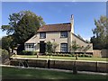
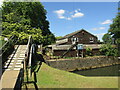
Lock-keepers cottage at Thames Lock
The cottage was restored by the National Trust.
Image: © don cload
Taken: 29 Sep 2018
0.08 miles
6
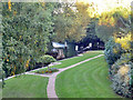
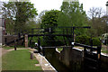
Entry gate to River Wey Navigation
This gate was added to the navigation in the 19th century, when rebuilding of Sunbury Lock on the Thames was accompanied by a lowering of the usual water level in the Thames at the confluence with the Wey. This resulted in the first Wey lock (Thames Lock) having insufficient depth when empty for all but the shallowest draught boats. The short but curved stretch of Wey above this gate and below Thames Lock is known as The Pound, and acts as the lower chamber of a staircase pair as required. It would appear boats can pass in it, if necessary.
Image: © Robin Webster
Taken: 1 Oct 2015
0.08 miles
7
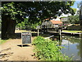
River Wey Navigation - Thames Lock
Weybridge - this lock is where the Wey Navigation meets the River Thames. The first lock was built in 1653, rebuilt in 1863 and renovated in 1996. Pleasure craft have long replaced the former barge traffic between London and Guildford.
www.weyriver.co.uk
Image: © Colin Smith
Taken: 8 Jul 2022
0.08 miles
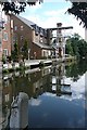
8
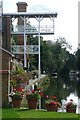
Apartments above Thames Lock
These are new, Google maps still showing the site as a building site. The balconies mimic the warehouse gantries that used to be at this location.
Image: © Graham Horn
Taken: 24 Aug 2008
0.08 miles
9
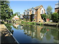
Weybridge - River Wey Navigation
A modern residential block overlooks the waterway by Thames Lock.
www.weyriver.co.uk
Image: © Colin Smith
Taken: 8 Jul 2022
0.09 miles
10
Apartments above Thames Lock
These have been built in the last few years. Google maps show this as a building site. The balconies are meant to mimic the old warehouse that stood at this location.
Image: © Graham Horn
Taken: 24 Aug 2008
0.09 miles