IMAGES TAKEN NEAR TO
Sandhills Meadow, SHEPPERTON, TW17 9HY
Introduction
This page details the photographs taken nearby to Sandhills Meadow, TW17 9HY by members of the Geograph project.
The Geograph project started in 2005 with the aim of publishing, organising and preserving representative images for every square kilometre of Great Britain, Ireland and the Isle of Man.

There are currently over 7.5m images from over14,400 individuals and you can help contribute to the project by visiting https://www.geograph.org.uk
Image Map
Images are licensed for reuse under creativecommons.org/licenses/by-sa/2.0
Notes
- Clicking on the map will re-center to the selected point.
- The higher the marker number, the further away the image location is from the centre of the postcode.
Image Listing (78 Images Found)
Images are licensed for reuse under creativecommons.org/licenses/by-sa/2.0
Image
Details
Distance
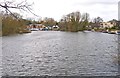
1
The Thames at Lower Halliford
Looking upstream towards Shepperton. The land on the left is Desborough Island, created when a cut-through was constructed in the 1930s to avoid the lengthy meanders at Lower Halliford.
Image: © mike smith
Taken: 22 Jan 2012
0.03 miles
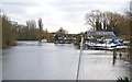
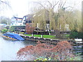
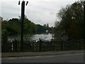
2
Sailing club by the River Thames
Image: © Oast House Archive
Taken: 19 Jul 2012
0.05 miles
3
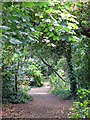
Footpath on Desborough Island opposite Sandhills Meadow
Image: © Mike Quinn
Taken: 11 Jul 2018
0.05 miles
4
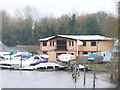
Moorings, Shepperton
On the banks of the River Thames by Russell Road, Shepperton.
www.british-history.ac.uk/report.aspx?compid=22224
Image: © Colin Smith
Taken: 23 Dec 2011
0.06 miles
5
Riverside, Shepperton
On the banks of the Thames by Russell Road, Shepperton.
www.british-history.ac.uk/report.aspx?compid=22224
Image: © Colin Smith
Taken: 23 Dec 2011
0.06 miles
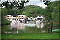
6
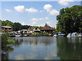
The River Thames and houses and boatyard, Sandhills Meadow
Image: © Mike Quinn
Taken: 11 Jul 2018
0.07 miles
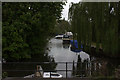
9
A loop of the Thames
The Thames loops around north of Desborough Island - an artificially-created island south of Shepperton. The island was formed in 1930s by the digging of a channel - the Desborough Cut - by the Thames Conservancy. Both island and cut are named after Lord Desborough who was at that time chairman of Thames Conservancy.
Image: © Eirian Evans
Taken: 13 Oct 2011
0.09 miles
10
The Thames at Lower Halliford
The river is quiet on this winter day. The view is looking upstream towards Shepperton.
Image: © mike smith
Taken: 22 Jan 2012
0.09 miles