IMAGES TAKEN NEAR TO
Vincent Drive, SHEPPERTON, TW17 8SW
Introduction
This page details the photographs taken nearby to Vincent Drive, TW17 8SW by members of the Geograph project.
The Geograph project started in 2005 with the aim of publishing, organising and preserving representative images for every square kilometre of Great Britain, Ireland and the Isle of Man.

There are currently over 7.5m images from over14,400 individuals and you can help contribute to the project by visiting https://www.geograph.org.uk
Image Map
Images are licensed for reuse under creativecommons.org/licenses/by-sa/2.0
Notes
- Clicking on the map will re-center to the selected point.
- The higher the marker number, the further away the image location is from the centre of the postcode.
Image Listing (66 Images Found)
Images are licensed for reuse under creativecommons.org/licenses/by-sa/2.0
Image
Details
Distance
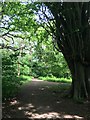
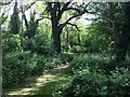
1
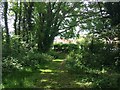
Secondary access to woodland at Halliford Park
Two paths directly enter the start of the wooded part from the road. Both join within just a few metres. Otherwise many paths lead into the diverse network of paths into the Tardis like woodland which is so varied with so many paths that it seems larger
Image: © Ad-lad
Taken: 8 May 2020
0.04 miles
2
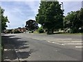
Verge and homes near Vincent Drive by the A244
The rather busy A244 is quiet in May 2020. Even when busy trees and verges to both sides in this district help greatly with air and noise pollution. Compare and contrast still parts of the windmill road estate and final feeder roads to Heathrow where a broad surrounding of poured concrete was the order of the day and remains in place choking much life and potential pollution scrubbers.
Image: © Ad-lad
Taken: 8 May 2020
0.04 miles
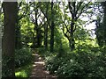
3
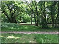
Crossing of informal paths in Halliford Park woodlands
One of several. This is in the more open western half of the woodlands which have lots of wood chipping and grass as opposed to cow parsley, borage, bramble, nettle, hazel, little nut trees and hawthorn as below canopy plants
Image: © Ad-lad
Taken: 8 May 2020
0.05 miles
4
Northwest access point to Halliford Park
West and south sides of park are full of ways in (and out) this proves to be the most natural and perhaps scenic of all for the main part of the woods in the park. From here several diverging paths come together. Upper Halliford Road adjoins the west side of the park.
Image: © Ad-lad
Taken: 8 May 2020
0.05 miles
5
Tall multi-trunk tree of Halliford Park
Regrettably I can’t confirm if this is a beech, but the well laid and well-trodden broad quite idyllic paths around here confirm many visitors make this a part of their several possible circuits available in the park. With the great log, a free tree-based attraction park with for most visitors being local far less cost and carbon footprint than to the similar trees in nearby counties.
Image: © Ad-lad
Taken: 8 May 2020
0.05 miles
6
Meadow-side tree tunnel Halliford Park
Near the playground this tree tunnel helps give a good noise buffer to the playground from the road
Image: © Ad-lad
Taken: 8 May 2020
0.05 miles
7
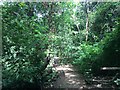
Halliford Park northern woodlands continued
Well worth the pleasant walk from Ashford or Sunbury, darker part of the wood which as is shown is still well connected by branching footpaths and not as dark as many Surrey woods (especially those of the North Downs and Greensand Hills)
Image: © Ad-lad
Taken: 8 May 2020
0.05 miles
8
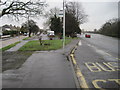
Upper Halliford Road, old and new
The older road on the left leads to the railway station.
Image: © Nigel Thompson
Taken: 31 Jan 2015
0.05 miles
9
Typical view of woodland in Halliford Park
The well-trod grass hints how close to the main road this is. A useful orienteering and in more wild contexts survival skill.
Image: © Ad-lad
Taken: 8 May 2020
0.05 miles
10

Great Log, Halliford Park
Many woods have a landmark great log such as this. A semi-natural feature, not only a host for insects, navigation aid, and scenic talking point but also a transient feature. In some decades another would normally be needed to remain put to replace it.
Image: © Ad-lad
Taken: 8 May 2020
0.06 miles