IMAGES TAKEN NEAR TO
Haslett Road, SHEPPERTON, TW17 8SU
Introduction
This page details the photographs taken nearby to Haslett Road, TW17 8SU by members of the Geograph project.
The Geograph project started in 2005 with the aim of publishing, organising and preserving representative images for every square kilometre of Great Britain, Ireland and the Isle of Man.

There are currently over 7.5m images from over14,400 individuals and you can help contribute to the project by visiting https://www.geograph.org.uk
Image Map
Images are licensed for reuse under creativecommons.org/licenses/by-sa/2.0
Notes
- Clicking on the map will re-center to the selected point.
- The higher the marker number, the further away the image location is from the centre of the postcode.
Image Listing (62 Images Found)
Images are licensed for reuse under creativecommons.org/licenses/by-sa/2.0
Image
Details
Distance
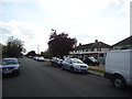
2
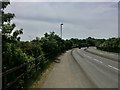
Upper Halliford Road
A terrace of houses in a truncated section of Upper Halliford Road, now bypassed by a new section of the A244 on a flyover over the railway and M3 motorway. The bollarded section in the background leads to Upper Halliford station.
Image: © Ian Capper
Taken: 10 Nov 2010
0.06 miles
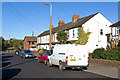
5
Ultra-Broad brief curve of Upper Halliford Road
This bizarrely brief (overall) dual carriageway section is relatively long compared to the minor junction (Nursery Road) it allegedly might help and from an era when large motor vehicles lacked anything like normal acceleration especially up the slope. Ripe for a retrenchment like the plans for a dualled Walton Bridge on the same road, it is unlikely the councils will agree funds and maintenance to restore trees that dominated the site. But some re-greening is currently the zeitgeist in national news and comparable boroughs (Waltham Forest) so Spelthorne may see what used to be which locally is clearly beautiful. It also pre-dates the motorway.
Image: © Ad-lad
Taken: 8 May 2020
0.10 miles
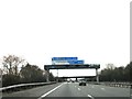
6
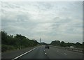
Ballard country: the M3 approaching Sunbury Cross
The M3 between Sunbury Cross and the M25 crosses largely level country, dotted with reservoirs, gravel pits and patches of suburbia. J.G. Ballard made his home for half a century in this affectless blank, and it forms the landscape of several of his novels.
Image: © Christopher Hilton
Taken: 26 Jun 2015
0.11 miles
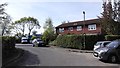
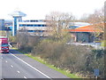
7

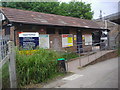
Upper Halliford Business Centre Car Park
AVMI Offices next to the M3.
Company web site : http://www.avmi.com/
Image: © James Emmans
Taken: 5 May 2016
0.11 miles
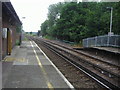
10
Industrial Estate by M3
The Dolphin Estate borders onto the M3 west of Sunbury Cross. The tower with its "hat" is an M3 landmark.
Image: © Colin Smith
Taken: 14 Dec 2011
0.11 miles