IMAGES TAKEN NEAR TO
Upper Halliford Road, SHEPPERTON, TW17 8SJ
Introduction
This page details the photographs taken nearby to Upper Halliford Road, TW17 8SJ by members of the Geograph project.
The Geograph project started in 2005 with the aim of publishing, organising and preserving representative images for every square kilometre of Great Britain, Ireland and the Isle of Man.

There are currently over 7.5m images from over14,400 individuals and you can help contribute to the project by visiting https://www.geograph.org.uk
Image Map
Images are licensed for reuse under creativecommons.org/licenses/by-sa/2.0
Notes
- Clicking on the map will re-center to the selected point.
- The higher the marker number, the further away the image location is from the centre of the postcode.
Image Listing (68 Images Found)
Images are licensed for reuse under creativecommons.org/licenses/by-sa/2.0
Image
Details
Distance
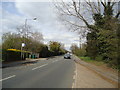
2
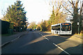
557 bus on Upper Halliford Road. A244
Destination: Addlestone Town Centre.
Image: © Robin Webster
Taken: 25 Nov 2017
0.03 miles
4
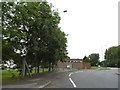
Roundabout on Gaston Bridge Road and Upper Halliford Road
Image: © David Howard
Taken: 2 Sep 2012
0.07 miles
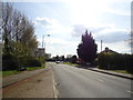
5
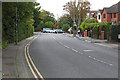
Upper Halliford Road
Looking south along Upper Halliford Road as it enters the village from the bypass roundabout.
Image: © Alan Hunt
Taken: 24 Sep 2015
0.11 miles
6
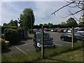
Grange Farm Estate car park
Residents can park bikes etc in their own plots, cars are parked in this somewhat landscaped car park. As with most car parks in Britain the surface is friendly to cars but not to trees and slowing run-off of the land being asphalt laid.
Image: © Ad-lad
Taken: 8 May 2020
0.12 miles
7
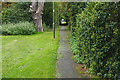
Footpath, Upper Halliford
The path from Upper Halliford Road along the south side of the recreation area to the Grange Farm estate.
Image: © Alan Hunt
Taken: 24 Sep 2015
0.13 miles
8
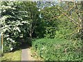
Upper Halliford Road to Sunbury ancient path, west end
Ancient path maintained principally by the local authorities
Image: © Ad-lad
Taken: 8 May 2020
0.13 miles
9
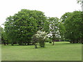
Hornbeam and Hawthorn, Halliford Park
Behind the hawthorn in flower is a group of large hornbeam trees. The park was the grounds of a large house, and there is a variety of trees including horse chestnut, apple and laburnum.
Image: © David Hawgood
Taken: 17 May 2006
0.13 miles
10
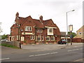
Trawlers, Upper Halliford
This public house has also been called "The Tickled Trout" and "The Bugle".
Image: © David Hawgood
Taken: 17 May 2006
0.13 miles