IMAGES TAKEN NEAR TO
Studios Road, SHEPPERTON, TW17 0QP
Introduction
This page details the photographs taken nearby to Studios Road, TW17 0QP by members of the Geograph project.
The Geograph project started in 2005 with the aim of publishing, organising and preserving representative images for every square kilometre of Great Britain, Ireland and the Isle of Man.

There are currently over 7.5m images from over14,400 individuals and you can help contribute to the project by visiting https://www.geograph.org.uk
Image Map
Images are licensed for reuse under creativecommons.org/licenses/by-sa/2.0
Notes
- Clicking on the map will re-center to the selected point.
- The higher the marker number, the further away the image location is from the centre of the postcode.
Image Listing (13 Images Found)
Images are licensed for reuse under creativecommons.org/licenses/by-sa/2.0
Image
Details
Distance
1
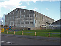
Shepperton film studios
One of the film stages in this large studio complex in Littleton. There is a children's play area serving the small housing estate to the west of the studios.
Image: © Alan Hunt
Taken: 2 Mar 2015
0.04 miles
2
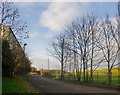
Studios Road. Littleton
With the hangar-like sheds of Shepperton Studios on the left, and the banks of Queen Mary Reservoir visible on the right. Seen in weak December sunshine.
Image: © Stefan Czapski
Taken: 6 Dec 2013
0.07 miles
3
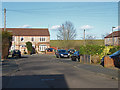
Astleham Way, Littleton
One of the estate roads in the small housing estate to the west of Shepperton film studios. This estate was built in the late 1970s on land surplus to requirements for the film studio. The embankment of the Queen Mary reservoir can be seen in the background.
Image: © Alan Hunt
Taken: 2 Mar 2015
0.12 miles
4
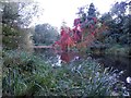
River Ash in Littleton (2)
The river flows very sluggishly here through what were once the grounds of Littleton House. The house still exists but much of the estate was subsequently developed to create Shepperton Studios.
Image: © Nigel Cox
Taken: 29 Sep 2015
0.12 miles
5
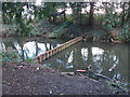
Sluice, River Ash
A barrier across the channel off the Ash that once fed the Littleton Park Lake. The grounds of this mansion were developed into the Shepperton film studios.
Image: © Alan Hunt
Taken: 2 Mar 2015
0.14 miles
6
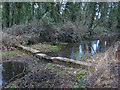
Old sluice, River Ash
Part of the old sluice on the channel to Littleton Park lake off the River Ash.
Image: © Alan Hunt
Taken: 2 Mar 2015
0.16 miles
7
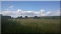
Thames Water
This is Thames Water land that surrounds the Queen Mary Reservoir. The pumping station is behind the clump of trees to the left.
This land is farmed with sheep and serves as an overflow car park to Shepperton Studios.
https://en.wikipedia.org/wiki/Queen_Mary_Reservoir
Image: © James Emmans
Taken: 3 Aug 2014
0.16 miles
8
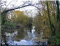
The River Ash, upstream from Squire's Bridge
The River Ash may have given its name to Ashford, but in all other respects is one of the least known rivers in this area - less well known, for instance, than the Wraysbury River or the Colne.
This stretch doesn't give the impression of having been heavily engineered - its bed is wide and must be fairly shallow. Flow is so sluggish that there are few places where the direction of flow can be made out. The shot was taken from a little bridge within sight of the David Lean Building, Shepperton Studios.
Image: © Stefan Czapski
Taken: 4 Dec 2013
0.18 miles
9
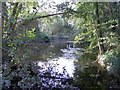
River Ash in Littleton (1)
The river flows very sluggishly here through what were once the grounds of Littleton House. The house still exists but much of the estate was subsequently developed to create Shepperton Studios.
Image: © Nigel Cox
Taken: 29 Sep 2015
0.18 miles
10
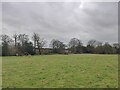
Nature reserve area close to Littleton
Littleton houses are hidden behind the row of trees.
Image: © James Emmans
Taken: 19 Feb 2021
0.19 miles