IMAGES TAKEN NEAR TO
Falcon Way, SUNBURY-ON-THAMES, TW16 6JW
Introduction
This page details the photographs taken nearby to Falcon Way, TW16 6JW by members of the Geograph project.
The Geograph project started in 2005 with the aim of publishing, organising and preserving representative images for every square kilometre of Great Britain, Ireland and the Isle of Man.

There are currently over 7.5m images from over14,400 individuals and you can help contribute to the project by visiting https://www.geograph.org.uk
Image Map
Images are licensed for reuse under creativecommons.org/licenses/by-sa/2.0
Notes
- Clicking on the map will re-center to the selected point.
- The higher the marker number, the further away the image location is from the centre of the postcode.
Image Listing (67 Images Found)
Images are licensed for reuse under creativecommons.org/licenses/by-sa/2.0
Image
Details
Distance
1
Part of Peregrine Road modern garden terraces
Housing in Lower Sunbury of a cheaper form for the quite affluent place, beautiful regardless of the smaller size than average.
Image: © Ad-lad
Taken: 8 May 2020
0.06 miles
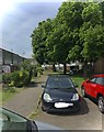
2
East access to Peregrine Road estate from Laytons Lane
A small green here is dwarfed by quite new hardstanding tucked away to the left
Image: © Ad-lad
Taken: 8 May 2020
0.08 miles
3
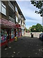
Peregrine Road groceries, salon, clothes cleaning (three shops)
This parade is supplemented by another about two hundred metres east. The other has a restaurant and pharmacy and similar grocery store among other outlets.
Image: © Ad-lad
Taken: 8 May 2020
0.10 miles
4
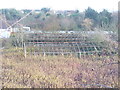
Dereliction by Nursery Road
Presumably Nursery Road in Upper Halliford took its name from this nursery which is obviously now not in use,
Image: © Colin Smith
Taken: 14 Dec 2011
0.11 miles
5
Spur cottages of Nursery Road
End wall of the 19th century terrace of simple architecture which is buffered from the new main course of the road by some gorse and other dry embankment adapted shrubs.
Image: © Ad-lad
Taken: 8 May 2020
0.11 miles
6
Westernmost home and end of spur of Nursery Road
Old course of the road causes this spur.
Image: © Ad-lad
Taken: 8 May 2020
0.11 miles
9
21st century houses, Nursery Road
Nurseries now these homes plus Green Belt. Planted borders mean some use of the sunlight over this land.
Image: © Ad-lad
Taken: 8 May 2020
0.11 miles
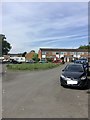
10
North east part of Peregrine Road
Relatively prettily designed apartments, some are socially rented and landscaping outlay is reasonable. Crossing the main road gives a short pleasant walk under the flyover bridge to Upper Halliford station. The zone is stubbornly outside of Zone 6 in transport.
Image: © Ad-lad
Taken: 8 May 2020
0.12 miles