IMAGES TAKEN NEAR TO
Fordbridge Park, Fordbridge Road, SUNBURY-ON-THAMES, TW16 6AT
Introduction
This page details the photographs taken nearby to Fordbridge Park, Fordbridge Road, TW16 6AT by members of the Geograph project.
The Geograph project started in 2005 with the aim of publishing, organising and preserving representative images for every square kilometre of Great Britain, Ireland and the Isle of Man.

There are currently over 7.5m images from over14,400 individuals and you can help contribute to the project by visiting https://www.geograph.org.uk
Image Map (Loading...)


Getting Data...Please wait
Leaflet Map data © OpenStreetMap
Images are licensed for reuse under creativecommons.org/licenses/by-sa/2.0
Notes
- Clicking on the map will re-center to the selected point.
- The higher the marker number, the further away the image location is from the centre of the postcode.
Image Listing (37 Images Found)
Images are licensed for reuse under creativecommons.org/licenses/by-sa/2.0
Image
Details
Distance
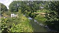
2
Access Bridge over the River Ash - rarely seen by drivers
The River Ash is a little known tributary of the Thames. It's a small river that runs to Ashford - hence the name. This is a straightened section, it was cut when the bridge was first built. A long time ago the river would have flowed along and over the road giving the name Fordbridge Road.
Image: © James Emmans
Taken: 10 Apr 2020
0.03 miles

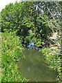
4
Bridge Over the River Ash
This bridge would have been a ford crossing many years ago.
Image: © James Emmans
Taken: 27 Jun 2015
0.06 miles
5
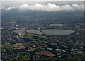
Walton-on-Thames from the air
Queen Elizabeth 2 reservoir is on the right, Knight reservoir and Bessborough reservoir are immediate to its left, Island Barn reservoir is beyond. The River Thames is in the foreground.
Image: © Thomas Nugent
Taken: 3 Aug 2015
0.07 miles
6
River Ash in Lower Sunbury
River Ash on its way to the Thames
Image: © James Emmans
Taken: 27 Jun 2015
0.08 miles
7
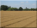
The River Ash east of Watersplash Farm buildings
Image: © Mike Quinn
Taken: 11 Jul 2018
0.09 miles
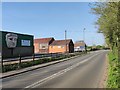
8
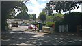
PTL Builders Merchant
Merchant on Fordbridge road that follows the River Thames.
Image: © James Emmans
Taken: 10 Apr 2020
0.09 miles
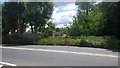
9
Watersplash Farm Entrance
The farm gets its name because the land is low lying and liable to extensive flooding. Some of the building are now used as a business park.
Image: © James Emmans
Taken: 10 Apr 2020
0.11 miles
10
Ploughed field east of Watersplash Farm buildings
Image: © Mike Quinn
Taken: 11 Jul 2018
0.13 miles