IMAGES TAKEN NEAR TO
Riverside, Lower Hampton Road, SUNBURY-ON-THAMES, TW16 5PW
Introduction
This page details the photographs taken nearby to Riverside, Lower Hampton Road, TW16 5PW by members of the Geograph project.
The Geograph project started in 2005 with the aim of publishing, organising and preserving representative images for every square kilometre of Great Britain, Ireland and the Isle of Man.

There are currently over 7.5m images from over14,400 individuals and you can help contribute to the project by visiting https://www.geograph.org.uk
Image Map
Images are licensed for reuse under creativecommons.org/licenses/by-sa/2.0
Notes
- Clicking on the map will re-center to the selected point.
- The higher the marker number, the further away the image location is from the centre of the postcode.
Image Listing (90 Images Found)
Images are licensed for reuse under creativecommons.org/licenses/by-sa/2.0
Image
Details
Distance

4
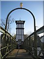
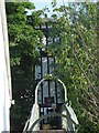
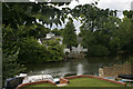
Sunbury Court Island: Footbridge and Tower
Sunbury Court Island used to be part of the estate of Sunbury Court Image until the death of its last private owner in 1910. The island's potential as a site for attractive riverside homes was subsequently recognised and construction was rapid after the end of the First World War. The 1920 Edition of the Ordnance Survey mapping shows the island as bare but by 1934 its entire length had been built on. However the dangers of living on an island in the Thames were brought home during the devastating floods of December 1927 when all the newly built bungalows had to be evacuated.
This is the footbridge and only dry access to the island. In the distance is the entrance tower, which was actually built to house a sewage pump, not to repel invaders...
The house on the downstream tip of the island was once owned by Ben Lyon and Bebe Daniels, who were the stars of the BBC radio comedy series ‘Life with the Lyons’ from 1951 to 1961.
Image: © Nigel Cox
Taken: 7 Dec 2008
0.03 miles
5
Bridge to Sunbury Court Island
This is the footbridge to the private Sunbury Court Island.
Image: © steve
Taken: 8 Jun 2005
0.03 miles
7
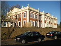
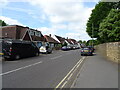
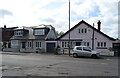
Sunbury Court Conference Centre
Sunbury Court was built in 1723 for John Witt, who was probably a retired master builder. Much sold, bought, and extended through the years it was last occupied as a residential home by William Horatio Harfield. When he died in 1910, the building became derelict and only when the Salvation Army purchased it in 1925 was it saved. Today the Salvation Army still run the Grade I listed building as an international conference centre. This view was taken from the Lower Hampton Road outside.
http://www.sunburycourt.co.uk/tour_sunbury/tour_sunbury.htm
Image: © Nigel Cox
Taken: 7 Dec 2008
0.03 miles
8
Sunbury Court Conference Centre
This is on the main road between Lower Sunbury and Hampton, by the Thames opposite Sunbury Court Island
Image: © steve
Taken: 8 Jun 2005
0.04 miles
9
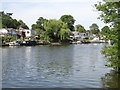
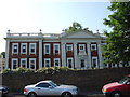
Sunbury Court Island
This is the eastern end of the island taken from Lower Hampton Road, Sunbury. The island was formerly known as Hayes Ait and has around thirty houses on it. Access is available to residents only.
Image: © David Kemp
Taken: 9 Jul 2009
0.05 miles