IMAGES TAKEN NEAR TO
Lower Hampton Road, SUNBURY-ON-THAMES, TW16 5PQ
Introduction
This page details the photographs taken nearby to Lower Hampton Road, TW16 5PQ by members of the Geograph project.
The Geograph project started in 2005 with the aim of publishing, organising and preserving representative images for every square kilometre of Great Britain, Ireland and the Isle of Man.

There are currently over 7.5m images from over14,400 individuals and you can help contribute to the project by visiting https://www.geograph.org.uk
Image Map
Images are licensed for reuse under creativecommons.org/licenses/by-sa/2.0
Notes
- Clicking on the map will re-center to the selected point.
- The higher the marker number, the further away the image location is from the centre of the postcode.
Image Listing (109 Images Found)
Images are licensed for reuse under creativecommons.org/licenses/by-sa/2.0
Image
Details
Distance
1
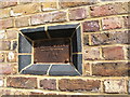
Plate showing the floodmark in 1894
Where the River Thames flooded Lower Hampton Road, Sunbury-on-Thames
Image: © Maggie Cox
Taken: 29 Jun 2013
0.01 miles
2
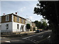
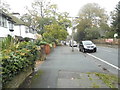
Lower Hampton Road, Sunbury-on-Thames
From the junction with French Street
Image: © Maggie Cox
Taken: 29 Jun 2013
0.02 miles
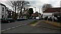
3
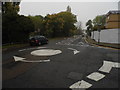
Thames Street at the junction of French Street
Image: © David Howard
Taken: 22 Oct 2012
0.03 miles
4
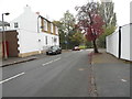
French Street, Sunbury
Looking towards Thames Street and the river.
Image: © David Howard
Taken: 22 Oct 2012
0.03 miles
6
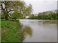
The muddy Thames at Sunbury, seen from Rivermead Island
This was the view downstream from Rivermead Island on May 2nd, 2012 - following the wettest April on record. The water level in the river was high (as high as at any time in the last 20 years, according to one local resident) but even more noticeable was the speed of flow and the muddiness of the water.
There may be limits to the validity of the comparison, but I'd suggest comparing this shot with Philip Halling's Image - which shows the darker, clearer colour of the Thames in more normal circumstances.
Rivermead Island is separated from the mainland by no more than a narrow channel, and is accessible from Thames Street by way of a footbridge. The big tree on the river bank in my shot is a plane - and a particularly fine specimen.
Image: © Stefan Czapski
Taken: 2 May 2012
0.06 miles
7
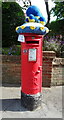
Yarn bombed George VI postbox on Lower Hampton Road
Postbox No. TW16 246.
See Image] for context.
Image: © JThomas
Taken: 27 May 2022
0.06 miles

10
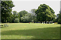
Rivermead Island
This is one of the few islands in the Thames to which there is public access. The trees in the farthest distance indicate the so-called Swan's Rest Island which was once an island in its own right but is now the eastern end of Rivermead Island.
Image: © David Kemp
Taken: 9 Jul 2009
0.07 miles