IMAGES TAKEN NEAR TO
Windsor Drive, ASHFORD, TW15 3JE
Introduction
This page details the photographs taken nearby to Windsor Drive, TW15 3JE by members of the Geograph project.
The Geograph project started in 2005 with the aim of publishing, organising and preserving representative images for every square kilometre of Great Britain, Ireland and the Isle of Man.

There are currently over 7.5m images from over14,400 individuals and you can help contribute to the project by visiting https://www.geograph.org.uk
Image Map
Images are licensed for reuse under creativecommons.org/licenses/by-sa/2.0
Notes
- Clicking on the map will re-center to the selected point.
- The higher the marker number, the further away the image location is from the centre of the postcode.
Image Listing (23 Images Found)
Images are licensed for reuse under creativecommons.org/licenses/by-sa/2.0
Image
Details
Distance
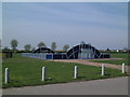
4
Ashford Park
Ashford Park Primary School as viewed from a footbridge over the Staines to Waterloo railway line.
Image: © David Squire
Taken: 22 Apr 2006
0.09 miles
5
Hengrove Recreation Ground
The play equipment certainly brightens up the otherwise rather flat Hengrove Recreation Ground. The recreation ground takes its name from the nearby Hengrove Farm - see also http://www.geograph.org.uk/photo/4159766
Image: © Marathon
Taken: 10 Sep 2014
0.11 miles
6
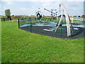
Play equipment in Hengrove Recreation Ground
The play equipment certainly brightens up the otherwise rather flat Hengrove Recreation Ground.
Image: © Marathon
Taken: 10 Sep 2014
0.12 miles
7
Ashford Park
This recreation ground contains this fenced multipurpose ball court.
Image: © David Squire
Taken: 22 Apr 2006
0.13 miles
8
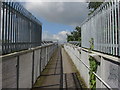
Railway Bridge, Ashford
The sloped access to the footbridge over the railway lines near Bronzefield prison.
Image: © Alan Hunt
Taken: 6 Aug 2012
0.14 miles
9
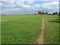
Ashford Park
The wide open expanse of Ashford Park with the banks of the former gravel pits in the distance.
Image: © Alan Hunt
Taken: 6 Aug 2012
0.14 miles
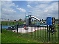
10

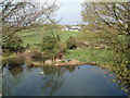
Fishing Lake, Ashford
The private fishing lake to the south of Ashford Park from the footbridge over the railway line.
Image: © Alan Hunt
Taken: 6 Aug 2012
0.14 miles