IMAGES TAKEN NEAR TO
Wye Close, ASHFORD, TW15 1BT
Introduction
This page details the photographs taken nearby to Wye Close, TW15 1BT by members of the Geograph project.
The Geograph project started in 2005 with the aim of publishing, organising and preserving representative images for every square kilometre of Great Britain, Ireland and the Isle of Man.

There are currently over 7.5m images from over14,400 individuals and you can help contribute to the project by visiting https://www.geograph.org.uk
Image Map
Images are licensed for reuse under creativecommons.org/licenses/by-sa/2.0
Notes
- Clicking on the map will re-center to the selected point.
- The higher the marker number, the further away the image location is from the centre of the postcode.
Image Listing (19 Images Found)
Images are licensed for reuse under creativecommons.org/licenses/by-sa/2.0
Image
Details
Distance
1
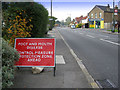
Feltham Road, Ashford, Middlesex
This photograph was taken at the time of the outbreak of foot and mouth disease in Surrey in 2007. It was quite a shock to see this sign in a residential area.
Image: © Rachel Keegan
Taken: 7 Oct 2007
0.07 miles
3
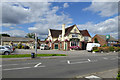
The Oaks, Feltham Road
In the Harvester chain.
Image: © Robin Webster
Taken: 12 Aug 2017
0.09 miles
10
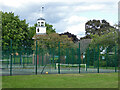
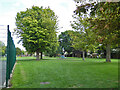
Clock tower and tennis courts, Clockhouse Lane Park
A surprising feature of a small park and recreation ground. A 1962 photograph reveals that this is the remaining core of an octagonal shelter or pavilion. Clockhouse Lane is named after Clock House, that was on the other side of the road, but now demolished. Was the clock, assuming there was one, transferred here?
Image: © Robin Webster
Taken: 12 Aug 2017
0.20 miles