IMAGES TAKEN NEAR TO
Vale Close, Strawberry Vale, TWICKENHAM, TW1 4SF
Introduction
This page details the photographs taken nearby to Vale Close, Strawberry Vale, TW1 4SF by members of the Geograph project.
The Geograph project started in 2005 with the aim of publishing, organising and preserving representative images for every square kilometre of Great Britain, Ireland and the Isle of Man.

There are currently over 7.5m images from over14,400 individuals and you can help contribute to the project by visiting https://www.geograph.org.uk
Image Map
Images are licensed for reuse under creativecommons.org/licenses/by-sa/2.0
Notes
- Clicking on the map will re-center to the selected point.
- The higher the marker number, the further away the image location is from the centre of the postcode.
Image Listing (91 Images Found)
Images are licensed for reuse under creativecommons.org/licenses/by-sa/2.0
Image
Details
Distance
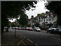
2
Waldegrave Park, Teddington
This is part of a row of fine old houses, some of which are still in sole occupation. These are viewed from Clavering Close.
Image: © Bill Boaden
Taken: 15 Aug 2010
0.11 miles
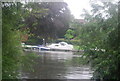
5
Riverside trees and high tide on the River Thames
Image: © N Chadwick
Taken: 25 Aug 2010
0.13 miles
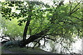
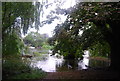
6
Riverside trees in the water, River Thames
Image: © N Chadwick
Taken: 25 Aug 2010
0.13 miles

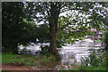
8
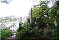
Obelisk on the Thames
This obelisk marks the maximum upstream point of the London Port Authority.
Image: © N Chadwick
Taken: 25 Aug 2010
0.13 miles