IMAGES TAKEN NEAR TO
Thames Eyot, Cross Deep, TWICKENHAM, TW1 4QL
Introduction
This page details the photographs taken nearby to Thames Eyot, Cross Deep, TW1 4QL by members of the Geograph project.
The Geograph project started in 2005 with the aim of publishing, organising and preserving representative images for every square kilometre of Great Britain, Ireland and the Isle of Man.

There are currently over 7.5m images from over14,400 individuals and you can help contribute to the project by visiting https://www.geograph.org.uk
Image Map
Images are licensed for reuse under creativecommons.org/licenses/by-sa/2.0
Notes
- Clicking on the map will re-center to the selected point.
- The higher the marker number, the further away the image location is from the centre of the postcode.
Image Listing (166 Images Found)
Images are licensed for reuse under creativecommons.org/licenses/by-sa/2.0
Image
Details
Distance
1

Flats overlooking the Thames at Twickenham
Just across from Eel Pie Island
Image: © Eirian Evans
Taken: 21 Oct 2010
0.01 miles
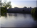
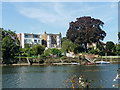
3
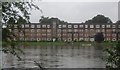
Thames Eyot, Twickenham
Not an island in the river, but a large block of flats. Surprisingly, it is not a converted institution but a purpose-built block, dating from 1935.
Image: © Robin Webster
Taken: 9 Sep 2012
0.02 miles
5
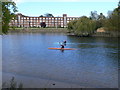
Canoeists on the Thames near Eel Pie Island
At the western end of the island.
Image: © Eirian Evans
Taken: 21 Oct 2010
0.05 miles
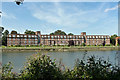
7
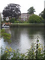
Large riverside houses at Strawberry Hill
Image: © Rod Allday
Taken: 24 Jun 2011
0.06 miles
8
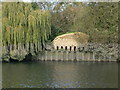
Home for birds and bats on Eel Pie Island
Sand Martin bank and Bat Hibernaculum at the western end of the island. Volunteers shifted 30 tonnes of sand, concrete, and other materials, by hand, over Eel Pie bridge to the site. Completed in 2009, the Bank has been rendered to appear as a natural sand bank, with draft-proofed housing for up to 80 sand martins as well as a number of bat roosts in the top.
Image: © Eirian Evans
Taken: 21 Oct 2010
0.07 miles
9
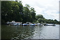
View of boats moored up at Eel Pie Island from The Embankment
Looking south-southwest.
Image: © Robert Lamb
Taken: 16 Jul 2016
0.07 miles
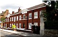
10
Houses overlooking River Thames
On the A310 Cross Deep.
Image: © Robin Webster
Taken: 9 Sep 2012
0.07 miles