IMAGES TAKEN NEAR TO
Strawberry Hill Road, TWICKENHAM, TW1 4QB
Introduction
This page details the photographs taken nearby to Strawberry Hill Road, TW1 4QB by members of the Geograph project.
The Geograph project started in 2005 with the aim of publishing, organising and preserving representative images for every square kilometre of Great Britain, Ireland and the Isle of Man.

There are currently over 7.5m images from over14,400 individuals and you can help contribute to the project by visiting https://www.geograph.org.uk
Image Map
Images are licensed for reuse under creativecommons.org/licenses/by-sa/2.0
Notes
- Clicking on the map will re-center to the selected point.
- The higher the marker number, the further away the image location is from the centre of the postcode.
Image Listing (138 Images Found)
Images are licensed for reuse under creativecommons.org/licenses/by-sa/2.0
Image
Details
Distance
1
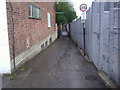
Footpath alongside railway line, Strawberry Hill
Image: © David Howard
Taken: 13 Apr 2008
0.04 miles
2
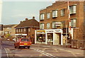
Shops in Strawberry Hill, 1984
These useful shops are viewed from the NW across the level crossing. In 1984 they comprised a car rental business, a greengrocer, a butcher and a deli.
Image: © Stephen Williams
Taken: Unknown
0.06 miles
3
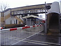
Level crossing and footbridge, Strawberry Hill
Image: © David Howard
Taken: 13 Apr 2008
0.06 miles
4
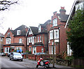
Waldegrave Gardens, Strawberry Hill
Built at the turn of the nineteenth century, large suburban properties such as these are typical of the area. The picture was taken looking towards Strawberry Hill House which is to be found behind a battlemented wall just around the corner in Waldegrave Road. This house was owned by the Waldegrave family during the C19, hence the local street-names.
Image: © David Kemp
Taken: 15 Dec 2010
0.07 miles
5

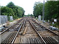
Looking south from Strawberry Hill station
This view is from the southbound platform at Strawberry Hill station (although from both platforms you can end up at Waterloo) looking across the level crossing on Tower Road. The line straight ahead continues to Teddington, Kingston and Wimbledon, whilst the line to the right is the branch line to Shepperton. The line through Strawberry Hill (the Kingston Loop) opened in 1863, but Strawberry Hill station did not open until 1873.
Image: © Marathon
Taken: 29 Jun 2011
0.08 miles
6
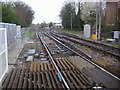
Railway line south of Strawberry Hill station
The main line on the left goes to New Malden and beyond, the branch line on the right ends in Shepperton.
Image: © David Howard
Taken: 13 Apr 2008
0.08 miles
7
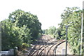
View south down the railway tracks towards London
Looking south.
Image: © Robert Lamb
Taken: 16 Jul 2016
0.08 miles
8
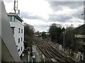
Railway junction at Strawberry Hill
This view is from the level crossing on Tower Road, just south of Strawberry Hill station. The line straight ahead continues to Teddington, Kingston and Wimbledon, whilst the line to the right is the branch line to Shepperton. The line through Strawberry Hill (the Kingston Loop) opened in 1863, but Strawberry Hill station did not open until 1873.
Image: © Marathon
Taken: 29 Jun 2011
0.08 miles
10
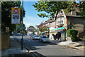
Post Office and shops, Tower Road
Strawberry Hill station is a bit further along.
Image: © Robin Webster
Taken: 22 Sep 2012
0.08 miles