IMAGES TAKEN NEAR TO
Heath Road, TWICKENHAM, TW1 4AX
Introduction
This page details the photographs taken nearby to Heath Road, TW1 4AX by members of the Geograph project.
The Geograph project started in 2005 with the aim of publishing, organising and preserving representative images for every square kilometre of Great Britain, Ireland and the Isle of Man.

There are currently over 7.5m images from over14,400 individuals and you can help contribute to the project by visiting https://www.geograph.org.uk
Image Map
Images are licensed for reuse under creativecommons.org/licenses/by-sa/2.0
Notes
- Clicking on the map will re-center to the selected point.
- The higher the marker number, the further away the image location is from the centre of the postcode.
Image Listing (117 Images Found)
Images are licensed for reuse under creativecommons.org/licenses/by-sa/2.0
Image
Details
Distance
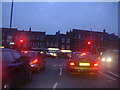
1

290 bus outside Twickenham Library entrance
On Heath Road
Image: © David Howard
Taken: 8 Dec 2008
0.05 miles
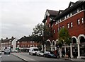
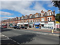
3
Heath Road from the junction with Cross Deep, Twickenham
Image: © Ruth Sharville
Taken: 12 Oct 2013
0.07 miles
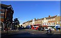
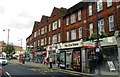
5
Cross Deep at the junction of King Street, Central Twickenham
Image: © David Howard
Taken: 13 Jan 2013
0.09 miles
8
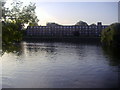
Thames Eyot, Twickenham
Not an island in the river, but a large block of flats. Surprisingly, it is not a converted institution but a purpose-built block, dating from 1935.
Image: © Robin Webster
Taken: 9 Sep 2012
0.12 miles
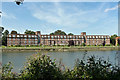
9

Flats overlooking the Thames at Twickenham
Just across from Eel Pie Island
Image: © Eirian Evans
Taken: 21 Oct 2010
0.12 miles