IMAGES TAKEN NEAR TO
Westmacott Drive, FELTHAM, TW14 9RJ
Introduction
This page details the photographs taken nearby to Westmacott Drive, TW14 9RJ by members of the Geograph project.
The Geograph project started in 2005 with the aim of publishing, organising and preserving representative images for every square kilometre of Great Britain, Ireland and the Isle of Man.

There are currently over 7.5m images from over14,400 individuals and you can help contribute to the project by visiting https://www.geograph.org.uk
Image Map
Images are licensed for reuse under creativecommons.org/licenses/by-sa/2.0
Notes
- Clicking on the map will re-center to the selected point.
- The higher the marker number, the further away the image location is from the centre of the postcode.
Image Listing (8 Images Found)
Images are licensed for reuse under creativecommons.org/licenses/by-sa/2.0
Image
Details
Distance
1
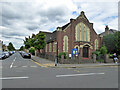
Southville Methodist Church
On the corner of Tachbrook Road and Bedfont Lane.
Image: © Robin Webster
Taken: 12 Aug 2017
0.12 miles
2
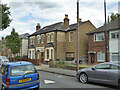
House with 'ghost' sign, Tachbrook Road
Three or four letters can be made out, but it is too faded to make any sense. In any case, it seems that part of the sign has been built over by the extension.
Image: © Robin Webster
Taken: 12 Aug 2017
0.13 miles
3
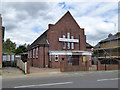
Calvary Free Grace Baptist Church
On Bedfont Lane.
Image: © Robin Webster
Taken: 12 Aug 2017
0.13 miles
4
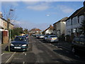
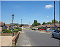
Colonial Road
Colonial Road heading to Bedfont Lane
Image: © Shaun Ferguson
Taken: 20 Feb 2013
0.17 miles
5
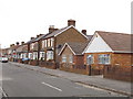
Warfield Road, Bedfont
Looking north.
Image: © David Hawgood
Taken: 25 Jan 2006
0.20 miles
7
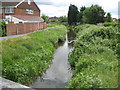
Longford River in East Bedfont
The Longford River is an artificial watercourse, built in 1638 on the instructions of King Charles I, and about 12 miles or about 19 kilometres long, that takes water off the River Colne and diverts it to provide a supply to Hampton Court Gardens. The river has had several different names in the past. For example the 1895 Ordnance Survey map refers to it as "Queen's or Cardinal's River".
This is the view looking downstream from the A315 Staines Road bridge. On the old Ordnance Survey map this was called White Bridge.
Image: © Nigel Cox
Taken: 8 May 2011
0.24 miles