IMAGES TAKEN NEAR TO
Hatton Road, FELTHAM, TW14 9PR
Introduction
This page details the photographs taken nearby to Hatton Road, TW14 9PR by members of the Geograph project.
The Geograph project started in 2005 with the aim of publishing, organising and preserving representative images for every square kilometre of Great Britain, Ireland and the Isle of Man.

There are currently over 7.5m images from over14,400 individuals and you can help contribute to the project by visiting https://www.geograph.org.uk
Image Map
Images are licensed for reuse under creativecommons.org/licenses/by-sa/2.0
Notes
- Clicking on the map will re-center to the selected point.
- The higher the marker number, the further away the image location is from the centre of the postcode.
Image Listing (40 Images Found)
Images are licensed for reuse under creativecommons.org/licenses/by-sa/2.0
Image
Details
Distance
8
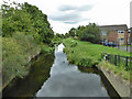
Duke of Northumberland's River
An artificial cut from River Colne to River Crane, originally built in the 16th century to augment the water supply for the Duke's mills. The building of Heathrow Airport required considerable diversion, but here it remains on the original route. Looking downstream.
Image: © Robin Webster
Taken: 12 Aug 2017
0.09 miles
9
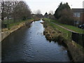
Duke of Northumberland's River
From Hatton Road bridge the Duke of Northumberland's River
Image: © Shaun Ferguson
Taken: 20 Feb 2013
0.09 miles
10
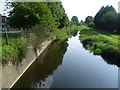
The Duke of Northumberland River at The Two Bridges
This western section of the Duke of Northumberland's River was constructed during the reign of King Henry VIIIth. It takes water from the River Colne and was designed to supplement the flow to existing mills. Here it is seen from Hatton Road.
The Two Bridges is so-named because Hatton Road also crosses the Longford River just to the right of here. Charles I ordered the construction of the totally artificial watercourse known as the Longford River to carry water from the River Colne to the water features in Bushy Park and then on to the Long Water in Home Park at Hampton Court. The Longford River opened in 1638.
To the west of the A30 and south of Heathrow Airport and its Southern Perimeter Road, the two waterways run parallel and it is possible to follow a track between them. There they are known as the Twin Rivers.
Image: © Marathon
Taken: 10 Sep 2014
0.09 miles