IMAGES TAKEN NEAR TO
Elmcroft Close, FELTHAM, TW14 9HJ
Introduction
This page details the photographs taken nearby to Elmcroft Close, TW14 9HJ by members of the Geograph project.
The Geograph project started in 2005 with the aim of publishing, organising and preserving representative images for every square kilometre of Great Britain, Ireland and the Isle of Man.

There are currently over 7.5m images from over14,400 individuals and you can help contribute to the project by visiting https://www.geograph.org.uk
Image Map
Images are licensed for reuse under creativecommons.org/licenses/by-sa/2.0
Notes
- Clicking on the map will re-center to the selected point.
- The higher the marker number, the further away the image location is from the centre of the postcode.
Image Listing (10 Images Found)
Images are licensed for reuse under creativecommons.org/licenses/by-sa/2.0
Image
Details
Distance
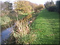
1
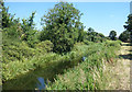
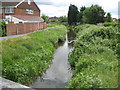
The Duke of Northumberland's River
The Duke's river and its younger companion the Longford River have flowed side by side all around the perimeter of Heathrow Airport. Now they have parted company, with the Longford heading for the Thames at Hampton Court and the Duke's continuing eastwards to join the River Crane just over 1km downstream from here.
https://en.wikipedia.org/wiki/Duke_of_Northumberland's_River
Image: © Des Blenkinsopp
Taken: 5 Jul 2017
0.01 miles
2
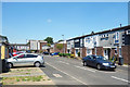
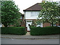
Elmcroft Close, Bedfont
A short residential cul de sac between Staines Road and the Duke of Northumberland's River.
Image: © Des Blenkinsopp
Taken: 5 Jul 2017
0.04 miles
3
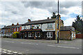
The Beehive, East Bedfont
A pub on A315 Staines Road.
Image: © Robin Webster
Taken: 12 Aug 2017
0.09 miles
4
Longford River, looking upstream
The Longford River is a 17th century artificial cut to supply Hampton Court with water from the River Crane.
Image: © Robin Webster
Taken: 12 Aug 2017
0.15 miles
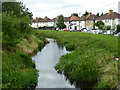
5
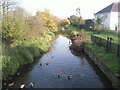
Longford River in East Bedfont
The Longford River is an artificial watercourse, built in 1638 on the instructions of King Charles I, and about 12 miles or about 19 kilometres long, that takes water off the River Colne and diverts it to provide a supply to Hampton Court Gardens. The river has had several different names in the past. For example the 1895 Ordnance Survey map refers to it as "Queen's or Cardinal's River".
This is the view looking downstream from the A315 Staines Road bridge. On the old Ordnance Survey map this was called White Bridge.
Image: © Nigel Cox
Taken: 8 May 2011
0.17 miles
6
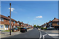
Residential Property on the "Poet's Estate" in North Feltham.
Residential Property on the "Poet's Estate" in North Feltham
Image: © Graham Newell
Taken: 9 May 2007
0.19 miles
8
Duke of Northumberland's River, Bedfont
This western section of the Duke of Northumberland's River was constructed during the reign of King Henry VIIIth. It takes water from the River Colne and was designed to supplement the flow to existing mills. This view looks eastwards from the footbridge on the path just north of Richmond Avenue in Bedfont.
Image: © Marathon
Taken: 24 Nov 2010
0.21 miles
9
Bank of the Duke of Northumberland's River
This western section of the Duke of Northumberland's River was constructed during the reign of King Henry VIIIth. It takes water from the River Colne and was designed to supplement the flow to existing mills. This view looks eastwards from near the footbridge on the path just north of Richmond Avenue in Bedfont and although the bank appears in the photograph to be accessible, there is no access.
Image: © Marathon
Taken: 24 Nov 2010
0.22 miles
10
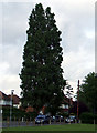
Ancient Lombardy Poplar Tree.
Ancient Poplar tree.
Image: © Graham Newell
Taken: 30 Apr 2007
0.23 miles