IMAGES TAKEN NEAR TO
Bedfont Close, FELTHAM, TW14 8LF
Introduction
This page details the photographs taken nearby to Bedfont Close, TW14 8LF by members of the Geograph project.
The Geograph project started in 2005 with the aim of publishing, organising and preserving representative images for every square kilometre of Great Britain, Ireland and the Isle of Man.

There are currently over 7.5m images from over14,400 individuals and you can help contribute to the project by visiting https://www.geograph.org.uk
Image Map
Images are licensed for reuse under creativecommons.org/licenses/by-sa/2.0
Notes
- Clicking on the map will re-center to the selected point.
- The higher the marker number, the further away the image location is from the centre of the postcode.
Image Listing (60 Images Found)
Images are licensed for reuse under creativecommons.org/licenses/by-sa/2.0
Image
Details
Distance
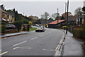
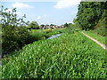
2
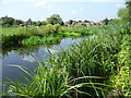
The Duke of Northumberland River near the Great South-West Road
This western section of the Duke of Northumberland's River was constructed during the reign of King Henry VIIIth. It takes water from the River Colne and was designed to supplement the flow to existing mills. Here it is approaching the Great South-West Road (A30). The houses on the other side of the horse-grazed field beyond are in Bedfont Close.
Just beyond the field and on this side of the houses is the Longford River. To the west of the A30 these two rivers run parallel and are known as the Twin Rivers.
Image: © Marathon
Taken: 10 Sep 2014
0.11 miles
5
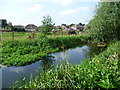
The Duke of Northumberland River near the Great South-West Road
This western section of the Duke of Northumberland's River was constructed during the reign of King Henry VIIIth. It takes water from the River Colne and was designed to supplement the flow to existing mills. Here it is approaching the Great South-West Road (A30). The houses on the other side of the horse-grazed field are in Bedfont Close.
Just beyond the field and on this side of the houses is the Longford River. To the west of the A30 these two rivers run parallel and are known as the Twin Rivers.
Image: © Marathon
Taken: 10 Sep 2014
0.14 miles
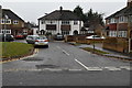
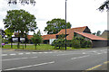
7
Impact Proms, Manor Barn, Bedfont. 2017
The aspect from Stanwell Road. The tree has now gone, and the company is being liquidated. The business was stated as 'Media representation services'.
Image: © Robin Webster
Taken: 12 Aug 2017
0.15 miles
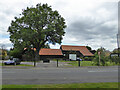
8
Impact Proms, Manor Barn, Bedfont, 2017
The aspect from Hatton Road. The tree on the left has now gone, and the company is being liquidated. The business was stated as 'Media representation services'.
Image: © Robin Webster
Taken: 12 Aug 2017
0.15 miles
9
The Duke of Northumberland River approaching the Great South-West Road
This western section of the Duke of Northumberland's River was constructed during the reign of King Henry VIII. It takes water from the River Colne and was designed to supplement the flow to existing mills. Here it is approaching the Great South-West Road (A30). The houses in the distance are in Bedfont Close.
Just on this side of the houses is the Longford River. To the west of the A30 these two rivers run parallel and are known as the Twin Rivers.
Image: © Marathon
Taken: 10 Sep 2014
0.15 miles