IMAGES TAKEN NEAR TO
Bethany Waye, FELTHAM, TW14 8HL
Introduction
This page details the photographs taken nearby to Bethany Waye, TW14 8HL by members of the Geograph project.
The Geograph project started in 2005 with the aim of publishing, organising and preserving representative images for every square kilometre of Great Britain, Ireland and the Isle of Man.

There are currently over 7.5m images from over14,400 individuals and you can help contribute to the project by visiting https://www.geograph.org.uk
Image Map
Images are licensed for reuse under creativecommons.org/licenses/by-sa/2.0
Notes
- Clicking on the map will re-center to the selected point.
- The higher the marker number, the further away the image location is from the centre of the postcode.
Image Listing (20 Images Found)
Images are licensed for reuse under creativecommons.org/licenses/by-sa/2.0
Image
Details
Distance
1
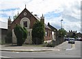
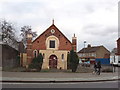
East Bedfont: Bethany Church
This former Baptist Chapel on the A315 Staines Road has a couple of unusual turrets at either side of the front facade. Imperial Road is to the right.
Image: © Nigel Cox
Taken: 8 May 2011
0.07 miles
2
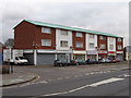
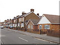
Shops in Staines Road, East Bedfont
On the south side of Staines Road, by Imperial Road.
Image: © David Hawgood
Taken: 25 Jan 2006
0.10 miles
3
Bethany Free Church, Bedfont
On Staines Road at the junction with Imperial Road. A church of the Assemblies of God, a Pentecostal group.
Image: © David Hawgood
Taken: 25 Jan 2006
0.10 miles
4
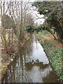
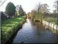
Longford River at Bedfont - water for Hampton Court
This is an artificial river about 12 miles long. The "This is Longford" website http://www.thisislongford.com/LongfordRiver.htm tells us it was dug on the orders of Charles I. In 1638 he wanted water from the Colne to supply Hampton Court. The river runs from Longford, now at the north east corner of Heathrow Airport. Until recently it ran under the airport, but with the building of the 5th terminal it has been diverted around the south of the airport. The river remained crown property, and some bridges over it have the royal cypher.
Image: © David Hawgood
Taken: 25 Jan 2006
0.13 miles
5
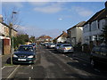
Colonial Road
Colonial Road heading to Bedfont Lane
Image: © Shaun Ferguson
Taken: 20 Feb 2013
0.16 miles
7
Warfield Road, Bedfont
Looking north.
Image: © David Hawgood
Taken: 25 Jan 2006
0.18 miles
8
Duke of Northumberland's River at Bedfont
This western section of the Duke of Northumberland's River was constructed during the reign of King Henry VIIIth. It takes water from the River Colne and was designed to supplement the flow to existing mills. This view looks westwards from the footbridge on the path just north of Richmond Avenue in Bedfont
Image: © Marathon
Taken: 24 Nov 2010
0.19 miles