1
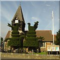
St Mary the Virgin, Bedfont
Celebrated and historic topiary, thought to represent peacocks.
Image: © Jon Bryant
Taken: 3 Oct 2005
0.10 miles
2
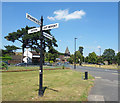
The Green on Staines Road, Bedford
Image: © David Howard
Taken: 26 Oct 2014
0.12 miles
3
Dudley Rd
Image: © N Chadwick
Taken: 7 Jun 2023
0.12 miles
4
Old Direction Sign - Signpost by the A315, Staines Road, East Bedfont
Cone finial - 4 arms; Middlesex shield by the A315, in parish of Feltham (Hounslow District), East Bedfont, junction of Staines Road with Bedfont Green Close, grassed area beyond pavement.
Surveyed
Milestone Society National ID: MX_TQ0873
Image: © Milestone Society
Taken: Unknown
0.12 miles
5
Fingerposts on Bedfont Green
Two arms have gone since 2012, the right turn to Bedfont as it's now accessed via the new link road from the roundabout, and the left turn to Hounslow which has been pulled off. The font actually appears to be Transport, the current design since 1964 so are probably not very old.
Image: © David Howard
Taken: 26 Oct 2014
0.13 miles
6
Old Style Signpost on the Green
On the post are a small badge and the letters MCC. Nothing to do with cricket, this is Middlesex County Council.
Image: © Des Blenkinsopp
Taken: 5 Jul 2017
0.13 miles
7
Bedfont - Housing Estate
Junction of Cedar Road and Sherbourne Road.
Image: © James Emmans
Taken: 2 Jan 2017
0.13 miles
8
Topiary outside St Mary the Virgin Church, East Bedfont
The yew trees outside the south door of the St Mary the Virgin Church must make one of the most striking entrances to any church. The dates on them give a hint of the dates involved. They were probably first cut into the shape of peacocks (or possibly fighting cocks) in 1704, and restored in 1865. They suffered a period of neglect during and after the Second World War through to 1990 but have now been fully restored.
There have been several explanations for the origin of these peacocks and the most common is that they represent two sisters who were proud and vain. The tale nowadays even assumes that the women were transformed into peacocks as a punishment for hanging around the gate to the churchyard every Sunday so that they could be admired while their more modesty dressed fellow parishioners filed quietly into church.
Image: © Marathon
Taken: 24 Nov 2010
0.13 miles
9
Burlington House, East Bedfont
The 18th century Burlington House stands just to the east of the parish church of St Mary, East Bedfont.
Image: © Marathon
Taken: 24 Nov 2010
0.14 miles
10
Burlington House, East Bedfont
The 18th century Burlington House stands just to the east of the parish church of St Mary.
Image: © Marathon
Taken: 24 Nov 2010
0.14 miles


