IMAGES TAKEN NEAR TO
Dudley Road, FELTHAM, TW14 8EH
Introduction
This page details the photographs taken nearby to Dudley Road, TW14 8EH by members of the Geograph project.
The Geograph project started in 2005 with the aim of publishing, organising and preserving representative images for every square kilometre of Great Britain, Ireland and the Isle of Man.

There are currently over 7.5m images from over14,400 individuals and you can help contribute to the project by visiting https://www.geograph.org.uk
Image Map
Images are licensed for reuse under creativecommons.org/licenses/by-sa/2.0
Notes
- Clicking on the map will re-center to the selected point.
- The higher the marker number, the further away the image location is from the centre of the postcode.
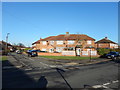
Image Listing (32 Images Found)
Images are licensed for reuse under creativecommons.org/licenses/by-sa/2.0
Image
Details
Distance
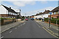
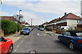
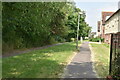
5
Bedfont - Housing Estate
Junction of Cedar Road and Sherbourne Road.
Image: © James Emmans
Taken: 2 Jan 2017
0.12 miles
9
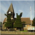
St Mary the Virgin, Bedfont
Celebrated and historic topiary, thought to represent peacocks.
Image: © Jon Bryant
Taken: 3 Oct 2005
0.20 miles