IMAGES TAKEN NEAR TO
Page Road, FELTHAM, TW14 8DT
Introduction
This page details the photographs taken nearby to Page Road, TW14 8DT by members of the Geograph project.
The Geograph project started in 2005 with the aim of publishing, organising and preserving representative images for every square kilometre of Great Britain, Ireland and the Isle of Man.

There are currently over 7.5m images from over14,400 individuals and you can help contribute to the project by visiting https://www.geograph.org.uk
Image Map
Images are licensed for reuse under creativecommons.org/licenses/by-sa/2.0
Notes
- Clicking on the map will re-center to the selected point.
- The higher the marker number, the further away the image location is from the centre of the postcode.
Image Listing (30 Images Found)
Images are licensed for reuse under creativecommons.org/licenses/by-sa/2.0
Image
Details
Distance
3
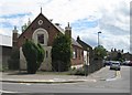
East Bedfont: Bethany Church
This former Baptist Chapel on the A315 Staines Road has a couple of unusual turrets at either side of the front facade. Imperial Road is to the right.
Image: © Nigel Cox
Taken: 8 May 2011
0.13 miles
4
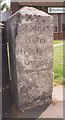
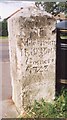
Old Milestone (north face) by the A315, Staines Road, Bedfont Green
Old Hounslow limestone square by the A315, in parish of Feltham (Hounslow District), Staines Road, Bedfont Green; outside Bedfont Library, on grass between path & library.
Inscription reads:- : 13 Miles / from / Hyde Park / Corner : : XIIi / Miles from / Hyde Park / Corner / 1743 :
Surveyed (Grade II listed)
Milestone Society National ID: MX_le13
Image: © Milestone Society
Taken: 9 Apr 2019
0.13 miles
5
Old Milestone (south face) by the A315, Staines Road, Bedfont Green
Old Hounslow limestone square by the A315, in parish of Feltham (Hounslow District), Staines Road, Bedfont Green; outside Bedfont Library, on grass between path & library.
Inscription reads:- : 13 Miles / from / Hyde Park / Corner : : XIIi / Miles from / Hyde Park / Corner / 1743 :
Surveyed (Grade II listed)
Milestone Society National ID: MX_le13
Image: © Milestone Society
Taken: 9 Apr 2019
0.13 miles
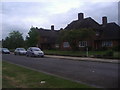
6
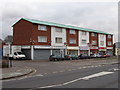
Shops in Staines Road, East Bedfont
On the south side of Staines Road, by Imperial Road.
Image: © David Hawgood
Taken: 25 Jan 2006
0.15 miles
7
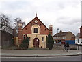
Bethany Free Church, Bedfont
On Staines Road at the junction with Imperial Road. A church of the Assemblies of God, a Pentecostal group.
Image: © David Hawgood
Taken: 25 Jan 2006
0.15 miles
10
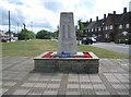
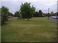
East Bedfont: The War Memorial
East Bedfont's War Memorial is on the east side of Grovestile Waye.
Comparing this image with Image it is evident that the names on the memorial have been repainted in the last year.
Image: © Nigel Cox
Taken: 8 May 2011
0.18 miles