IMAGES TAKEN NEAR TO
Radius Park, Faggs Road, FELTHAM, TW14 0NJ
Introduction
This page details the photographs taken nearby to Radius Park, Faggs Road, TW14 0NJ by members of the Geograph project.
The Geograph project started in 2005 with the aim of publishing, organising and preserving representative images for every square kilometre of Great Britain, Ireland and the Isle of Man.

There are currently over 7.5m images from over14,400 individuals and you can help contribute to the project by visiting https://www.geograph.org.uk
Image Map
Images are licensed for reuse under creativecommons.org/licenses/by-sa/2.0
Notes
- Clicking on the map will re-center to the selected point.
- The higher the marker number, the further away the image location is from the centre of the postcode.
Image Listing (108 Images Found)
Images are licensed for reuse under creativecommons.org/licenses/by-sa/2.0
Image
Details
Distance
1
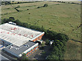
Air Canada shed near Heathrow from the air
On St Anthony's Way at Radius Park.
Image: © Thomas Nugent
Taken: 19 Jun 2015
0.05 miles
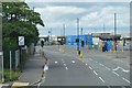
9
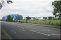
Grazing for horses by Faggs Road
The large blue building is an hotel. The other buildings behind all relate to airport activity though the horses are not under the flight path.
Image: © Bill Boaden
Taken: 26 May 2022
0.12 miles
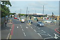
10
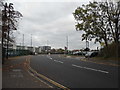
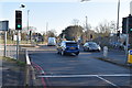
Hatton Road at the junction of Faggs Road
On the perimeter of Heathrow Airport
Image: © David Howard
Taken: 26 Oct 2014
0.12 miles