IMAGES TAKEN NEAR TO
St. Albans Farm, Staines Road, FELTHAM, TW14 0HH
Introduction
This page details the photographs taken nearby to St. Albans Farm, Staines Road, TW14 0HH by members of the Geograph project.
The Geograph project started in 2005 with the aim of publishing, organising and preserving representative images for every square kilometre of Great Britain, Ireland and the Isle of Man.

There are currently over 7.5m images from over14,400 individuals and you can help contribute to the project by visiting https://www.geograph.org.uk
Image Map
Images are licensed for reuse under creativecommons.org/licenses/by-sa/2.0
Notes
- Clicking on the map will re-center to the selected point.
- The higher the marker number, the further away the image location is from the centre of the postcode.
Image Listing (33 Images Found)
Images are licensed for reuse under creativecommons.org/licenses/by-sa/2.0
Image
Details
Distance
3
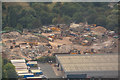
London Borough of Hounslow : Ron Smith Recycling
A recycling centre seen from a plane heading into Heathrow.
Image: © Lewis Clarke
Taken: 28 Aug 2018
0.09 miles
4
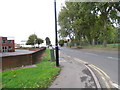
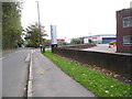
Green Lane at the junction of Staines Road, Hounslow
Image: © David Howard
Taken: 27 Oct 2013
0.09 miles
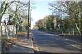
7
Fairway Close trading estate, Hounslow
Image: © David Howard
Taken: 27 Oct 2013
0.13 miles
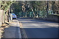
8
The entrance to Fairway Trading Estate on Green Lane
Image: © David Howard
Taken: 27 Oct 2013
0.13 miles
9
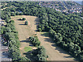
Hounslow Heath golf centre from the air
On approach to the south runway at Heathrow from the east.
Image: © Thomas Nugent
Taken: 19 Jun 2015
0.14 miles