IMAGES TAKEN NEAR TO
Carlton Avenue, FELTHAM, TW14 0EH
Introduction
This page details the photographs taken nearby to Carlton Avenue, TW14 0EH by members of the Geograph project.
The Geograph project started in 2005 with the aim of publishing, organising and preserving representative images for every square kilometre of Great Britain, Ireland and the Isle of Man.

There are currently over 7.5m images from over14,400 individuals and you can help contribute to the project by visiting https://www.geograph.org.uk
Image Map
Images are licensed for reuse under creativecommons.org/licenses/by-sa/2.0
Notes
- Clicking on the map will re-center to the selected point.
- The higher the marker number, the further away the image location is from the centre of the postcode.
Image Listing (11 Images Found)
Images are licensed for reuse under creativecommons.org/licenses/by-sa/2.0
Image
Details
Distance
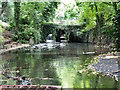
1
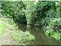
Branch of River Crane
The river splits around a long island over this stretch. The island is on the right. This seems to be connected with a former snuff mill that used this river branch, the other branch being the mill bypass.
Image: © Robin Webster
Taken: 14 Sep 2012
0.09 miles
4
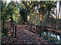
Footbridge on the London Loop
The London Loop path goes alongside the River Crane for most of the length between Hayes and Whitton. This is on the edge of Hounslow Heath where it crosses a drainage channel entering the Crane.
Image: © Des Blenkinsopp
Taken: 25 Nov 2011
0.11 miles
5
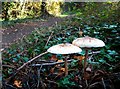
Parasol Mushrooms by the London Loop
The appropriately named Parasol Mushroom, Macrolepiota procera, is a reasonably common variety of edible fungus. http://en.wikipedia.org/wiki/Macrolepiota_procera
These are growing beside the London Loop path as it goes beside the River Crane on the edge of Hounslow Heath.
Image: © Des Blenkinsopp
Taken: 25 Nov 2011
0.12 miles
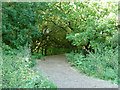
6
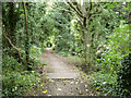
London Loop path
Here the long distance path runs beside the River Crane, hidden on the right. In the foreground is a small bridge over a drain.
Image: © Robin Webster
Taken: 14 Sep 2012
0.12 miles
7
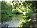
River Crane
Viewed from the London Loop long distance path.
Image: © Robin Webster
Taken: 14 Sep 2012
0.17 miles
8
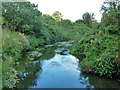
River Crane
Looking downstream from the bridge used by the London Loop long distance path.
Image: © Robin Webster
Taken: 14 Sep 2012
0.20 miles
9
Site of former snuff mill, River Crane
Looking upstream on the western branch of the river. The eastern branch, the natural course, bypasses the mill site via weirs. Above the mill there was formerly a substantial mill pond. The leat for the upper set of mills at Hounslow Powder Mills was tapped off it.
Image: © Robin Webster
Taken: 14 Sep 2012
0.20 miles
10
Bridge over former Hounslow Powder Mills leat
The leat is of some length, a consequence of the modest fall of the River Crane over this stretch. The track is used by the London Loop long distance path.
Image: © Robin Webster
Taken: 14 Sep 2012
0.20 miles