IMAGES TAKEN NEAR TO
Crown Road, TWICKENHAM, TW1 3EQ
Introduction
This page details the photographs taken nearby to Crown Road, TW1 3EQ by members of the Geograph project.
The Geograph project started in 2005 with the aim of publishing, organising and preserving representative images for every square kilometre of Great Britain, Ireland and the Isle of Man.

There are currently over 7.5m images from over14,400 individuals and you can help contribute to the project by visiting https://www.geograph.org.uk
Image Map
Images are licensed for reuse under creativecommons.org/licenses/by-sa/2.0
Notes
- Clicking on the map will re-center to the selected point.
- The higher the marker number, the further away the image location is from the centre of the postcode.
Image Listing (61 Images Found)
Images are licensed for reuse under creativecommons.org/licenses/by-sa/2.0
Image
Details
Distance
1
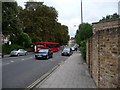
Crown Road, St Margarets
Running between the A316 and the A305.
Image: © Christine Johnstone
Taken: 20 Aug 2010
0.02 miles
2
![St Margarets buildings [2]](https://s1.geograph.org.uk/geophotos/07/04/22/7042213_e180a5ce_120x120.jpg)
St Margarets buildings [2]
Substantial terraced houses in St Margarets Road.
St Margarets is a suburb in the London Borough of Richmond upon Thames, alongside the River Thames, some 9 miles southwest of central London. St Margarets became one of the first garden suburbs when the St Margarets Estate was laid out for family houses in 1854.
Image: © Michael Dibb
Taken: 19 Aug 2021
0.05 miles
3
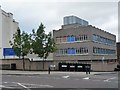
Twickenham Film Studios
Set up in 1913 on the site of a skating rink. Much more information at www.twickenhamstudios.com
Image: © Christine Johnstone
Taken: 20 Aug 2010
0.05 miles
4

Twickenham - The Barons
Large semi detached houses in an estate.
Image: © James Emmans
Taken: 13 Nov 2016
0.06 miles
5
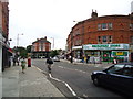
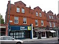
Shops, St Margarets Road, St Margarets
Image: © Stacey Harris
Taken: 6 Aug 2011
0.06 miles
6
![St Margarets buildings [5]](https://s0.geograph.org.uk/geophotos/07/04/22/7042276_c7e108cd_120x120.jpg)
St Margarets buildings [5]
Baronsfield Road, typical of the St Margarets area.
St Margarets is a suburb in the London Borough of Richmond upon Thames, alongside the River Thames, some 9 miles southwest of central London. St Margarets became one of the first garden suburbs when the St Margarets Estate was laid out for family houses in 1854.
Image: © Michael Dibb
Taken: 19 Aug 2021
0.07 miles
7
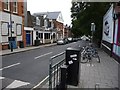
Amyand Park Road, St Margarets
Buildings on one side, the railway line on the other.
Image: © Christine Johnstone
Taken: 20 Aug 2010
0.07 miles
8
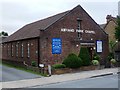
Amyand Park Chapel
A reformed evangelical Baptist church in Amyand Park Road.
Image: © Christine Johnstone
Taken: 20 Aug 2010
0.07 miles
9
The Broadway, St Margarets Road
A parade of shops by St Margarets railway station.
Image: © Christine Johnstone
Taken: 20 Aug 2010
0.07 miles
10
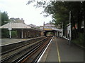
St Margarets station
St Margarets station was opened by the London & South Western Railway in 1876 on the existing line from Waterloo to Windsor. This view looks towards the road bridge at St Margarets Road and on up the line towards Richmond.
Image: © Marathon
Taken: 15 Sep 2010
0.07 miles