IMAGES TAKEN NEAR TO
York Street, TWICKENHAM, TW1 3BW
Introduction
This page details the photographs taken nearby to York Street, TW1 3BW by members of the Geograph project.
The Geograph project started in 2005 with the aim of publishing, organising and preserving representative images for every square kilometre of Great Britain, Ireland and the Isle of Man.

There are currently over 7.5m images from over14,400 individuals and you can help contribute to the project by visiting https://www.geograph.org.uk
Image Map
Images are licensed for reuse under creativecommons.org/licenses/by-sa/2.0
Notes
- Clicking on the map will re-center to the selected point.
- The higher the marker number, the further away the image location is from the centre of the postcode.
Image Listing (383 Images Found)
Images are licensed for reuse under creativecommons.org/licenses/by-sa/2.0
Image
Details
Distance
1

Aragon Road at the junction of Richmond Road
Image: © David Howard
Taken: 22 Nov 2015
0.02 miles
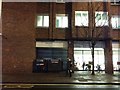
3
Pizza in the darkness, Twickenham
The open storefront contrasts with all the dark closed shops either side.
Image: © David Howard
Taken: 21 Nov 2016
0.03 miles
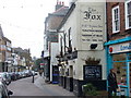
4
The Eel Pie
I don't fancy a pie'n'pint here if it's eel! I'll stick to a pint. Historic Church Street, Twickenham.
Image: © Colin Smith
Taken: 22 Feb 2009
0.04 miles
5

The Eel Pie, Twickenham
This is a picture of the then-new Eel Pie pub in 1982. At the time it offered a welcome alternative to the domination of Watneys and Courage pups in the area, and always offered a good range of well kept ales. The building was previously a pair of shops, as is apparent from the frontage.
Image: © Stephen Williams
Taken: Unknown
0.04 miles
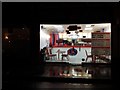
6
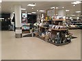
Inside Waitrose Twickenham
The security guard gave me a funny look but he didn't say anything. I'll ask him next time and if it's OK will take some more. You don't get many of these on Streetview but some shops have been covered indoors.
Image: © David Howard
Taken: 18 Feb 2017
0.04 miles
7
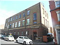
Twickenham Telephone Exchange (1)
Situated in Garfield Road TW1 3JS, this TE would appear to date from the 1930s when several TEs were built in Greater London. It has the code LWTWI and provides telephone and broadband services to approximately 13,907 residential and 875 non-residential premises in the Twickenham area. A KX100 plus telephone box can be seen in front of the TE to the left of the photo.
Image: © David Hillas
Taken: 23 Jul 2022
0.04 miles
9
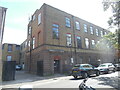
Twickenham Telephone Exchange (2)
This photo shows the front and side of the TE in Garfield Road. It used to have POPesgrove numbers until the late 1960s, Popes Grove being a residential road in Twickenham. This TE now has 0208 - 891, 892 xxxx numbers plus some Outer London numbers.
Image: © David Hillas
Taken: 23 Jul 2022
0.05 miles
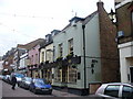
10
Church Street
Delightful historic street in central Twickenham, full of historic buildings.
Image: © Colin Smith
Taken: 22 Feb 2009
0.05 miles