IMAGES TAKEN NEAR TO
Elmwood Avenue, FELTHAM, TW13 7QA
Introduction
This page details the photographs taken nearby to Elmwood Avenue, TW13 7QA by members of the Geograph project.
The Geograph project started in 2005 with the aim of publishing, organising and preserving representative images for every square kilometre of Great Britain, Ireland and the Isle of Man.

There are currently over 7.5m images from over14,400 individuals and you can help contribute to the project by visiting https://www.geograph.org.uk
Image Map
Images are licensed for reuse under creativecommons.org/licenses/by-sa/2.0
Notes
- Clicking on the map will re-center to the selected point.
- The higher the marker number, the further away the image location is from the centre of the postcode.
Image Listing (63 Images Found)
Images are licensed for reuse under creativecommons.org/licenses/by-sa/2.0
Image
Details
Distance
5
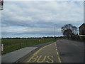
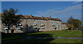
Elmwood Avenue overlooking Hanworth Park
Image: © David Howard
Taken: 14 Apr 2013
0.06 miles
6
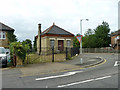
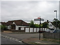
Valve house, Kempton Park - Fortis Green water main
On the corner of Felthambrook Way and Elmwood Avenue. The underground water main runs beside Felthambrook Way/Forest Road here.
Image: © Robin Webster
Taken: 16 Sep 2012
0.10 miles
8
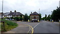
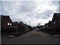
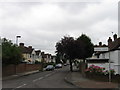
Junction of Forest Road and Elmwood Avenue
A rare Rover P5 is being taken out for a spin on this Sunday morning.
Image: © Jonathan Billinger
Taken: 5 Jul 2015
0.11 miles
9
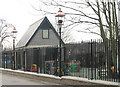
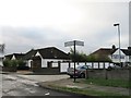
St George, Castle Way, Hanworth - Church hall
Image: © John Salmon
Taken: 10 Mar 2005
0.14 miles
10
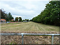
Course of Kempton Park - Fortis Green water main
This large underground water main was originally kept clear of any buildings over it to a substantial width, and consequently looked rather like an abandoned railway on the surface. More recently, building has been permitted over it.
Image: © Robin Webster
Taken: 16 Sep 2012
0.14 miles