IMAGES TAKEN NEAR TO
Queens Way, FELTHAM, TW13 7NS
Introduction
This page details the photographs taken nearby to Queens Way, TW13 7NS by members of the Geograph project.
The Geograph project started in 2005 with the aim of publishing, organising and preserving representative images for every square kilometre of Great Britain, Ireland and the Isle of Man.

There are currently over 7.5m images from over14,400 individuals and you can help contribute to the project by visiting https://www.geograph.org.uk
Image Map
Images are licensed for reuse under creativecommons.org/licenses/by-sa/2.0
Notes
- Clicking on the map will re-center to the selected point.
- The higher the marker number, the further away the image location is from the centre of the postcode.
Image Listing (70 Images Found)
Images are licensed for reuse under creativecommons.org/licenses/by-sa/2.0
Image
Details
Distance
1
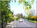
Sunbury Way
Suburban Hanworth with laburnum and forsythia blooming outside the gardens.
Image: © Colin Smith
Taken: 2 May 2008
0.12 miles
2
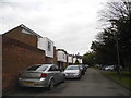
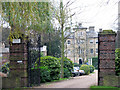
Tudor Court, Hanworth
Typical 1960-70s houses on a private cul-de-sac
Image: © David Howard
Taken: 14 Apr 2013
0.14 miles
3
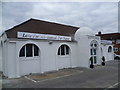
Baitul Wahid Mosque, Snakey Lane, Hanworth
Not all mosques are large buildings or purpose built. The Baitul Wahid Mosque in Snakey Lane was until recently offices for Pitney Bowes and that was how it appeared on Street View at the time I photographed this, although it did have a notice on it saying "Freehold for sale". The facade seen here facing Snakey Lane has been changed but not the proportions or colour. The words above the windows speak for themselves.
Image: © Marathon
Taken: 4 Apr 2012
0.15 miles
4
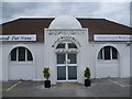
Entrance to the Baitul Wahid Mosque, Snakey Lane, Hanworth
Not all mosques are large buildings or purpose built. The Baitul Wahid Mosque in Snakey Lane was until recently offices for Pitney Bowes and that was how it appeared on Street View at the time I photographed this, although it did have a notice on it saying "Freehold for sale". The facade seen here facing Snakey Lane has been changed but not the proportions or colour. The message to the left of the entrance says "Love For All - Hatred For None".
Image: © Marathon
Taken: 4 Apr 2012
0.15 miles
9
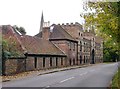
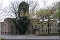
Tudor Court, Castle Way, Hanworth Park
Old 'West Middlesex' is an area where odd little pockets of an earlier landscape survive surrounded by 20th century suburban development. There is little in Hanworth dating back further than the 1930's - so this rather eccentric building, just south of St George's church, came as quite a surprise.
The name reflects the fact that a much older house once stood here - a hunting lodge used by Henry VIII and other Tudor monarchs. Little seems to remain from those times - though a length of high wall at the SW end of the churchyard looks Tudor. In any case, the Tudor house was replaced during the 18th century by a house that has in its turn been demolished - though fragments from that era can be seen from the churchyard.
What you see here - converted to residential use - would appear to be a gatehouse and stables. The Middlesex edition of Pevsner's 'The Buildings of England' suggests a date of 'c.1850-60', and dismisses the present building as 'of no merit'. I think that's too harsh - Tudor Court does its bit to liven up these otherwise rather humdrum suburbs. The whole is almost a folly - with curious touches, like stained glass (or painted) windows protected by cast-iron grilles.
Ian Yarham has contributed a more comprehensive history of the houses which have occupied the site: http://www.geograph.org.uk/photo/2887473
Image: © Stefan Czapski
Taken: 3 Nov 2012
0.16 miles
10
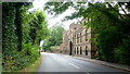
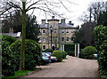
Castle Way, Hanworth
The building is Tudor House, originally a stable block for Hanworth Park; now residential.
Image: © Jonathan Billinger
Taken: 5 Jul 2015
0.16 miles