IMAGES TAKEN NEAR TO
Mono Lane, FELTHAM, TW13 7NF
Introduction
This page details the photographs taken nearby to Mono Lane, TW13 7NF by members of the Geograph project.
The Geograph project started in 2005 with the aim of publishing, organising and preserving representative images for every square kilometre of Great Britain, Ireland and the Isle of Man.

There are currently over 7.5m images from over14,400 individuals and you can help contribute to the project by visiting https://www.geograph.org.uk
Image Map
Images are licensed for reuse under creativecommons.org/licenses/by-sa/2.0
Notes
- Clicking on the map will re-center to the selected point.
- The higher the marker number, the further away the image location is from the centre of the postcode.
Image Listing (84 Images Found)
Images are licensed for reuse under creativecommons.org/licenses/by-sa/2.0
Image
Details
Distance
1
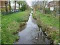
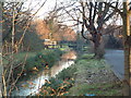
The Longford River in the centre of Feltham
The Longford River was constructed in 1638 to take water from the River Colne. This would then supplement the water supply to Hampton Court and enable the development of the water features in the park. Here the Longford River is viewed from the High Street in the centre of Feltham as it heads towards Hanworth Park.
Image: © Marathon
Taken: 4 Apr 2012
0.04 miles
2
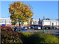
Leisure West Sprawl
Wide expanse of modern entertainment and restaurant facilities between Feltham High Street and Business Park.
Image: © Colin Smith
Taken: 6 Nov 2007
0.05 miles
3
Longford River
A rather faded sign near the spot where this photograph was taken reads: "Notice. Longford River. The Police have received instructions to take into custody any person found trespassing damaging or destroying the banks or the freeboard of the River. By Order."
Image: © David Squire
Taken: 28 Dec 2005
0.08 miles
4
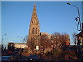
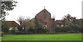
St Catherine's House
This building retains the spire of the former St Catherine's Church. It has been nicknamed the "Feltham Folly" somewhat unkindly. It is now occupied by Hounslow Homes, tasked with managing some 16,500 council homes, was formed in 2002 as one of the first eight arms length management organisations (ALMOs) in the country
Image: © David Squire
Taken: 28 Dec 2005
0.10 miles
5
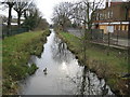
Longford River in Feltham
The Longford River is an artificial watercourse constructed in 1638 at the instigation of King Charles I to improve the water supply to Hampton Court Palace and to provide a source for the water features in the landscaped gardens. It takes off from the River Colne at Longford and runs for about 19 kilometres, before discharging into the River Thames.
The white noticeboard on the right advises that "The Police have received instructions to take into custody any person found trespassing, damaging or destroying the banks or the freeboard of the River. By Order." So there... Incidentally in this context the freeboard of a watercourse is the vertical distance between the water level and the level at which the water would burst one of its banks in a flood event.
Image: © Nigel Cox
Taken: 8 Feb 2009
0.10 miles
6
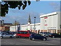
Leisure West, Feltham
Cinema, ten pin bowling and large area of car parking near to Feltham High Street.
Image: © Colin Smith
Taken: 6 Nov 2007
0.10 miles
7

Feltham: Former Feltham Community Association building
Boarded up, fenced off and closed, this building on the High Street used to house Feltham's Community Association, including a Citizens' Advice Bureau. It is reputedly to be razed to the ground and replaced by a new Skills Centre run by West Thames College. The Feltham Community Association was formed in 1972 so obviously this structure was not purpose-built for them. The Ordnance Survey map edition of 1871 shows this to be the site of the Railway Inn.
Image: © Nigel Cox
Taken: 8 Feb 2009
0.12 miles
8
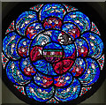
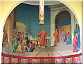
St Lawrence, Feltham - Stained glass window
Image: © John Salmon
Taken: 20 Mar 2017
0.12 miles