IMAGES TAKEN NEAR TO
Bel Lane, FELTHAM, TW13 6BY
Introduction
This page details the photographs taken nearby to Bel Lane, TW13 6BY by members of the Geograph project.
The Geograph project started in 2005 with the aim of publishing, organising and preserving representative images for every square kilometre of Great Britain, Ireland and the Isle of Man.

There are currently over 7.5m images from over14,400 individuals and you can help contribute to the project by visiting https://www.geograph.org.uk
Image Map
Images are licensed for reuse under creativecommons.org/licenses/by-sa/2.0
Notes
- Clicking on the map will re-center to the selected point.
- The higher the marker number, the further away the image location is from the centre of the postcode.
Image Listing (18 Images Found)
Images are licensed for reuse under creativecommons.org/licenses/by-sa/2.0
Image
Details
Distance

2
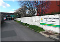
Dairy Crest's Hanworth Depot
Situated off Hampton Road West is this depot for milk delivery floats.
Image: © Peter Kazmierczak
Taken: 17 Apr 2016
0.12 miles
9
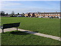
Looking across the park to Nene Gardens
From Saxon Avenue looking across the park to Nene Gardens
Image: © Shaun Ferguson
Taken: 15 Feb 2013
0.18 miles